
Assistance for Building Façade Assessment
Building owners need to routinely assess the condition of their building façades for many reasons, including compliance with façade inspection ordinances, to check for deterioration, to monitor known deterioration, and to plan for maintenance and capital repairs. Traditional methods for façade inspection include ground-based visual observations and hands-on inspection using various means of access, which both have limitations. Access to building façades for hands-on inspection can range from straightforward to very complex. The more complexity involved in accessing the façade, the higher the costs, and the less likely that building owners will routinely assess the conditions of their building façades, potentially allowing deterioration to occur unchecked.
Visual ground-based assessment may be a suitable technique for low-rise buildings that do not feature significant articulation in the façade. Taller buildings result in a greater angle of incidence for ground-based viewing or require the viewer to be further away from the building, requiring visual aids such as binoculars. Distance and limited viewing angles can make the detection of potential issues difficult. Low-rise buildings featuring significant articulation also may not be suitable for visual review. The articulation can hide significant deterioration that cannot be seen due to the angle of incidence, distance, or the need to be above the item in question.
Hands-on inspection is the “gold standard” for detecting deterioration and potential hazards. Temporary access for inspection, such as aerial lifts, suspended staging, or industrial rope access, is required. However, access methods have practical constraints and can be costly. Aerial lifts are an efficient and low-cost way to access building façades, but require open, supportive, and level ground around the building, and are limited in height. Suspended staging is generally not limited by height or ground access, but can be costly to set up, requires tieback anchors safety lines, and cannot cover a wide area very quickly. Industrial rope access is also not generally limited by height or ground space. Still, it requires more staff to cover the same amount of area and more tieback anchor availability for safety lines.
Small Unmanned Aerial Systems (sUAS or Drone) technology offers a new means of efficiently documenting building façade conditions with less time and cost, but with limitations that are specific to the technology itself. Drone technology can be a suitable way to complement visual building façade condition assessments or as a tool for planning hands-on inspections by identifying areas of concern. Equipment, such as an infrared camera, can be added to the drone to obtain additional information during the façade survey.
FAA Regulation
All commercial drone operations are regulated by the Federal Aviation Administration (FAA) and require a certified operator to perform the work. Before September 2016, operators performing commercial work required a Section 333 exemption, which mandated possession of a pilot’s license. After September 2016, the FAA enacted Part 107. The necessary Part 107 certification is acquired by fee and examination. Upon completion, the certificate holder is authorized to perform work in Class G airspace, uncontrolled airspace outside the controlled airspace of airports, and below controlled airspace where commercial aircraft travel. Currently, the FAA requires recertification every 24 months.
Operation Process
A Small Unmanned Aerial System (sUAS) operation can generally be broken down into four stages: establish the scope of survey, operation planning, on-site operation, and postprocessing/data deliverable. There are several items and steps to consider within these stages. The following is not a complete list. Operators may find some aspects to be more critical than others.
Establish Scope of Drone Survey
For a successful drone survey, the survey team and drone operator should understand the project, the survey goals, obstacles that may affect the survey, and expected deliverables. Asking the right questions can help the project team optimize the survey.
The most crucial consideration when proposing a drone operation is the airspace restrictions, if any, at the project site. The FAA provides an ArcGIS UAS Map that, when entering an address, will provide the most current airspace restrictions, including maximum allowable altitude above ground level. If the project is within proximity to an airport, some additional authorization may be required.
Operation Planning
Operation planning begins once the goals of the façade assessment are established. During this stage, verify the scope and the agreed-upon final product. Once an operation date is finalized, there are a few essential factors to consider. It is possible the height restriction at the project site has changed, so make sure to revisit the airspace restrictions and be sure you still have the proper authorizations in place. Verify that there are no temporary flight restrictions (TFR) in place in the proposed area of observation. TFRs will be put in place during large public events or VIP movements. TFRs are generally considered no-fly zones and will require additional FAA approval. Some municipalities may have their own ordinance, which may require you to submit information about your operation. Be sure to confirm these restrictions by checking online or calling local law enforcement.
Several airports participate in LAANC (Low Altitude Authorization and Notification Capability), which allows for instant authorization assuming the flight will remain at or below the published altitude limit in the FAA’s ArcGIS UAS Map. If operation at a higher altitude than the published limit is required, you will need to submit a request through one of the LAANC providers, identifying the location of your operation and why you are requesting to fly higher than the posted maximum. Depending on the region, you should get a response back between two and seven days. If you need to operate in an airspace that does not participate in LAANC, you will be required to submit an airspace authorization through the FAA’s Drone Zone portal. The response time for these will vary, so it is important to submit this as soon as you know you need it to get approval before your operation date.
The weather forecast for the upcoming operation is an important consideration. While a bright sunny day is nice and can be acceptable, data collection may be affected by excessive brightness. High winds, rain, or other precipitation will require rescheduling. An overcast day can be best for photography, but keep in mind that heavy clouds can affect the GPS signal.
It is best to make an initial site visit to identify obstructions and drone takeoff and landing locations. If this is not feasible, best practice is to use available aerial imagery software to mark proposed takeoff and landing areas, understanding these could change at the site. Be sure to consider areas that restrict operation around pedestrians and moving vehicles due to safety concerns. At the same time, be sure to mark potential obstructions to operation.
It is vital to have a checklist to ensure that you have everything you need for a safe and successful operation.
On-site Operation
The site visit date has arrived, and Mother Nature has provided appropriate weather. As an sUAS operator, the priority is always safety. The first task when arriving on-site should be to walk around and verify potential takeoff/landing locations. Take note of any obstructions, such as trees, overhead wires, high traffic areas, construction equipment, and anything that may not have been obvious from the initial in-office planning. Be aware of nearby tall buildings and other objects that could cause issues with GPS connectivity. Follow the preflight checklist to minimize issues. Before takeoff, be sure visual observer(s) and all team members are clear on their tasks.
Once airborne, keep the goals of the project in mind. If capturing images manually as opposed to an automated flight path, consider focusing on areas that may otherwise be inaccessible to the project team either due to visibility or safety. Always be aware of the surroundings, and do not get distracted. Remain confident in your abilities to control situations. During takeoff and landing, always communicate with the team members so that they can help verify the area is clear of any pedestrians or other obstructions. Remember, safety is the priority.
After the first flight, review the images with the project team to verify you are getting the desired results. Make sure to back up all data.
Postprocessing/Deliverables
Once back in the office, the final step is to generate the agreed-upon deliverable. Data backup and organization are critical. A detailed folder structure by building, elevation, or whatever other attribute is helpful. Consider keeping multiple copies of the unedited data. In its simplest form, the deliverable might consist of formatted and organized images. More detailed deliverables are also possible, including annotated photos, videos, imaging sequencing, or other data processing (e.g., if additional equipment, such as infrared cameras, is used). Understand the deliverable options and educate the client regarding options for report presentation. Use this information to focus and optimize the report for its intended purpose.
Case Studies
Masonry Bell Tower
The masonry bell tower on a college campus exhibited signs of deterioration of the spires at the top of the tower (Figure 1). The masonry bell tower has a church adjacent to its west elevation for approximately 50% of the tower height. A one-story building connects to the bell tower on the east elevation. The south elevation is located within a limited access courtyard. The north elevation was unencumbered by other structures but had a sloped ground, making access via mobile lift impractical. Previously, the college accessed the bell tower exterior utilizing a crane basket, which cost $5,000 per day, plus mobilization.

Figure 1. Masonry Bell Tower.
Interior access allowed for visual observations of the northeast and southeast corner spires from small roofs behind the spires. However, the northwest and southwest spires did not have access. Also, the entire bell tower above the spire level was inaccessible. Ground access for a binocular survey was generally uninhibited but, due to the angle of incidence, it was not possible to see the tops of the step-backs up the tower and the masonry spires on the west elevation.
The college considered multiple options for temporary access, including crane basket, industrial rope access, drone access, and supported scaffolding. They quickly ruled out the crane basket and supported scaffolding due to the cost. They also ruled out industrial rope access due to costs and safety concerns. Therefore, the façade assessment was completed from the ground and utilized a drone to focus on areas not visible from the ground.
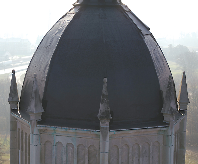
Figure 2. Drone image of the top of Bell Tower.
For this project, the weather was less than cooperative, with a clear day forecast several days out, turning into a day with constant precipitation. As a result, it took two days to capture the information rather than a single day. This is something to consider when planning a project; consider building in an extra day for contingency in requesting authorization (e.g., local air traffic control, local officials, building users, etc.). Once airborne, the drone captured video and still images of areas not visible from the ground, and allowed for close-up, head-on photos in other areas (Figures 2 and 3). The drone has some limitations. It cannot remove small falling hazards, such as loose mortar, cannot remove samples, and cannot sound masonry to detect delaminations. The drone typically cannot fly closer than 10 feet to the building due to the potential for a wind gust to carry it into the building.

Figure 3. Drone head-on close-up image of deteriorated masonry.
Overall, using a drone allowed a more cost-effective and time-efficient façade assessment that quickly identified potential hazards for the college to evaluate and determine how best to address.
Supplemental Access
The authors recently completed condition assessments on three buildings on a university campus using aerial lifts and ground-based observations. A drone supplemented the survey for multiple reasons. First, the time available with the aerial lift was limited, and there was a need to focus on areas of significant distress. The drone was useful in determining whether areas of significant distress existed that were not visible from the ground. Second, despite having an aerial lift and roof access, some areas of the building façades were still inaccessible due to low roofs being in the way or an inability to get the aerial lift close enough to the building. The drone provided up-close views of these façades. Third, using a drone allowed for whole-building infrared scans to determine whether air leakage or heat loss was potentially occurring through the walls, windows, or roofs. And finally, the facility group wanted to employ new technology to evaluate its potential application to the remaining buildings on campus.
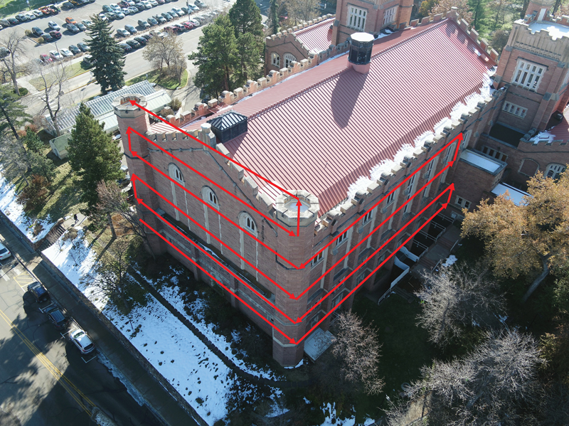
Figure 4. Preprogrammed flight path for façade mapping.
The drone captured video and still images of the building façades and roofs. The drone was preprogrammed to photo map each building first (Figure 4) and then free-flew to look at areas inaccessible from the aerial lift and capture specific close-up, head-on images. The infrared scanning occurred after sunset and provided an overview of the overall thermal and air leakage performance of the buildings (Figure 5).
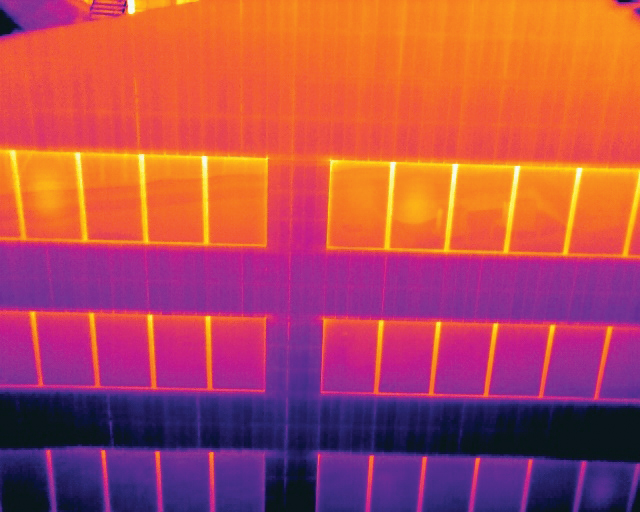
Figure 5. Infrared image of façade.
Working on this campus was challenging and required significant coordination with the class schedule and the university safety office. Knowing the class schedule is very helpful to maximize the time of the drone in the air, as well as knowing when it needs to be on the ground during periods of substantial pedestrian activity. Also, notification of building and grounds occupants is especially important, as the drone flew outside the windows of professors’ offices, classrooms, administrative offices, and performance spaces.
The drone information helped supplement the visual assessment and other evaluation work. More importantly, it allowed a visual review of areas completely inaccessible using other methods. The university can now decide how soon to access these areas to address issues discovered by the drone observations.
Summary
Drones can be an incredibly useful and efficient tool with the potential to save both time and money. They provide a means of access to obtain visual information rapidly and potentially more detailed, when other means of access are too restrictive or costly. Also, drones provide another cost-effective perspective to view the building façade even when façade access is possible. Like any new technology, education and understanding of limitations are imperative to implement it effectively. Proper planning is necessary to obtain an effective drone survey that adds to the understanding of the building façade. As a drone operator in the AEC industry, it is essential to remember that the primary goal is to enhance engineering work by safely generating useful data that provides value. Being an integral member of the survey team is crucial to providing that value.■