
Part 1: A 32-year Déjà-vu
Mexico City’s geoseismic design challenges arise from its unique local geology combined with high tectonic activity. This article discusses the challenges that continue to grow, as the center of the ruins of the Aztec capital has turned into the most prominent modern metropolis of Latin America, with economic growth that demands taller buildings. The response of the regional soils has repeatedly and destructively materialized in the form of soil basin amplification phenomena (one- and two-dimensional) that manifested as seismic waves propagating through the natural valley’s topography. This topography is filled with soft, high-plasticity elastic clays that were a part of the drained lake that once existed below the City. A vivid recent reminder was the 2017 Mw7.1 Puebla-Morelos Earthquake, a déjà-vu precisely on the 32nd anniversary of the September 19th, 1985, Michoacán Ms8.0 Earthquake, with an epicenter 400 kilometers (km) (~250 miles) away from the city center. The 1985 toll of more than 39,000 deaths and nearly 10,000 building collapses was attributed to a multi-resonance of seismic incident waves, soil deposits, and structures. In 2017, the soil amplification repeated from a different type of earthquake that was 120 km (~78 mi) away, with only slightly different recorded motions than those in 1985. This article provides an evaluation of selected recorded motions within the City that correlates with observed differences in the level and distribution of damage between the two events that occurred 32 years apart. The evaluation is a combined result of experiences and studies performed over more than 2 decades by the co-authors – designers at WSP and researchers at NTUA, and the recent findings by the ATC reconnaissance team that traveled to Mexico City, which is gratefully recognized for contributions to this article. This is Part One of two articles that focus on the geotechnical and structural design challenges of Mexico City.
Geology and Tectonics
Mexico City is mostly built on a basin formerly occupied by the ancient Lake Texcoco that has evolved since the Aztec arrival in the 13th century, as shown in Figure 1. Currently, the lake is completely drained from its original water area of 700 km2 (270 mi2) except for a small lake near Xochimilco.

Figure 1. Evolution of the lake system at Mexico City Valley (Ovando-Shelley et al., 2013).
New human settlements between the 16th and 18th centuries by the conquering Spaniards caused the biggest impacts on the built environment due to further deforestation, agriculture, pasture lands, construction, and land reclamation. The Spaniards tried to control the water by replacing the Aztec system of dikes and canals with streets and squares, draining the lakes and removing forestland. These actions resulted in severe floods, some of which drowned the city for months and even years on end.
Moreover, the Valley of Mexico is mainly formed by volcanic materials, while the surface layers consist of alluvial deposits, mostly lacustrine clays. A large part of Mexico City is built on top of highly plastic soft clay sediments interlayered with thin silt and sand layers. The clayey deposits of Mexico City are fairly unique, containing volcanic ash, and are characterized by an unusually high plasticity index (PI ≈ 200-300), a natural water content (wn ≈ 200 – 600), and low shear wave velocity, Vs, within the 40 to 90 m/s (~130 – 300 ft/s) range. This saturated deposit is extremely compressible and has caused settlements of 9 m (~30 ft) since the beginning of the 20th century (Tapia et al., 2000) which, in turn, have induced damaging differential settlements in many monuments, structures, and infrastructure built in the former lake area (Figure 2).
Figure 2. Continuing sinking of the Mexico City lake bed causing visible differential settlements in buildings.
In the past few decades, the City has grown from about 78 km2 (30 mi2) to a metropolis about 100 times larger, as shown in Figure 3. The lakebed continues to sink by up to 30 cm/year (~12 in/year), as groundwater is extracted to support its more than 20 million inhabitants. Development of tall buildings with deeper basements over the past two decades has increased exponentially to accommodate the rapid growth.
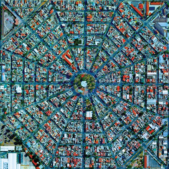
Figure 3. Mexico’s Colonia Federal harmonic and radiant geometry from above. Courtesy of Digital Globe, 2015.
The problematic soil conditions, continuous water extraction, and frequent strong seismic activity have presented unique challenges in the design and construction of Mexico City. The Spanish settlers identified these difficulties since the mid-16th century after observing their buildings sinking. In 1550, Cervantes de Salazar, author and rector in Mexico, concerned about the continuous settlements and seismic activity, introduced a height limit of two stories (Cervantes de Salazar, 1978). Per Rosenblueth & Ovando (1991), this was probably the first rule for earthquake-resistant design in the Americas.
Currently, a Performance-Based Design (PBD) approach has been followed in the seismic design of new tall buildings. PBD also presents challenges, many of which are a result of the behavior of the unique soft soils that seem to have similar behavior over past strong earthquakes.
A 32-year Earthquake Déjà-vu
A vivid and destructive manifestation of such amplification was observed in Mexico City during both the 1985 Ms8.0 Michoacán and 2017 Mw7.1 Puebla-Morelos earthquakes. The 1985 event occurred in the subduction zone offshore of western Mexico, nearly 400 km (~250 mi) from the city. Yet, it caused enormous damage with tens of thousands of deaths mostly concentrated in the northwestern part of the Mexico City lake region. It became abundantly clear that the soft clay layers were the main culprit of the disaster, having amplified the ±2 seconds period of the motion of the incoming waves. As shown in Figure 4, the 2017 event occurred as the result of normal faulting in Central Mexico at a depth of approximately 50 km (~30 mi), approximately 120 km (75 mi) away from Mexico City. The damage was significant in the City, with 40 building collapses and at least 400 deaths, but lower than those in 1985 thanks to mainly the improved local seismic code. Although the two events had different seismological characteristics of magnitude, distance from the epicenter, and orientation, they generated quite similar soil amplification effects.
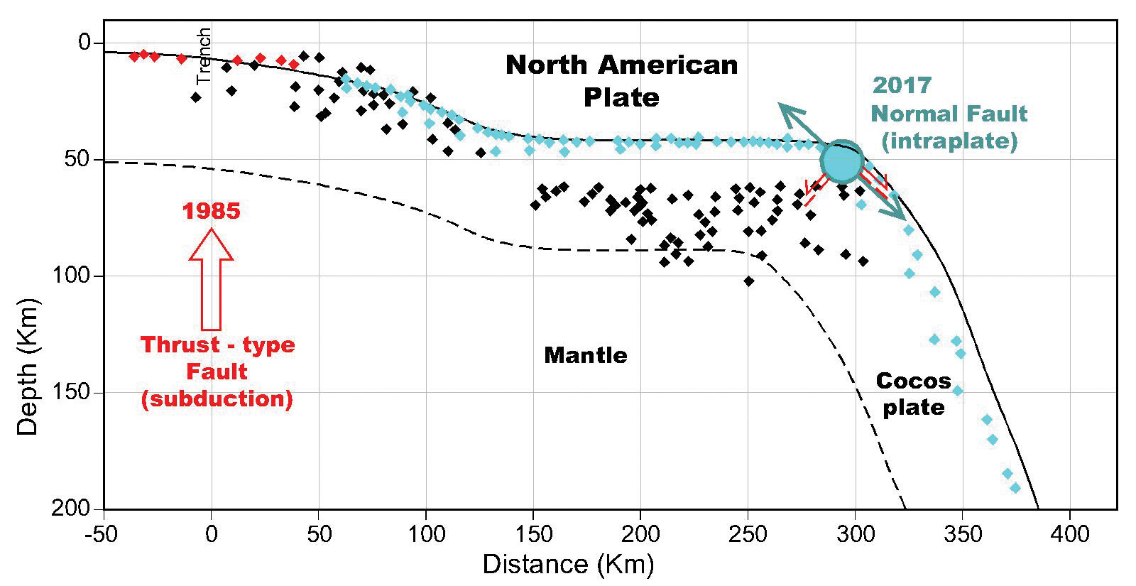
Figure 4. Mechanisms of 1985 Michoacán and 2017 Puebla-Morelos earthquakes (USGS, 2017).
The incident waves that constitute the seismic motion, propagating from the bedrock through the soil, undergo changes in both their amplitude and frequency characteristics. Since the amplitude usually increases, the term “soil amplification” is used to describe the phenomenon, as discussed in a previous article (STRUCTURE, Nikolaou, February 2008). The effects of soil amplification on a structure depend on its location with respect to the lake area, as shown in Figure 5 (Nikolaou et al., 2018), that is largely described by the three zones defined in the Mexican Building Code (OGDF, 2017): Hilly (I), Transition (II), and Lake (III). More specifically, a typical geotechnical profile within the lakebed varies in thickness H and, as shown in Figure 6, consists of an upper fill deposit, a regional soft plastic clay, and dense layers of silty sand and dense clay that reach a stiff deposit referred to as “bedrock.”
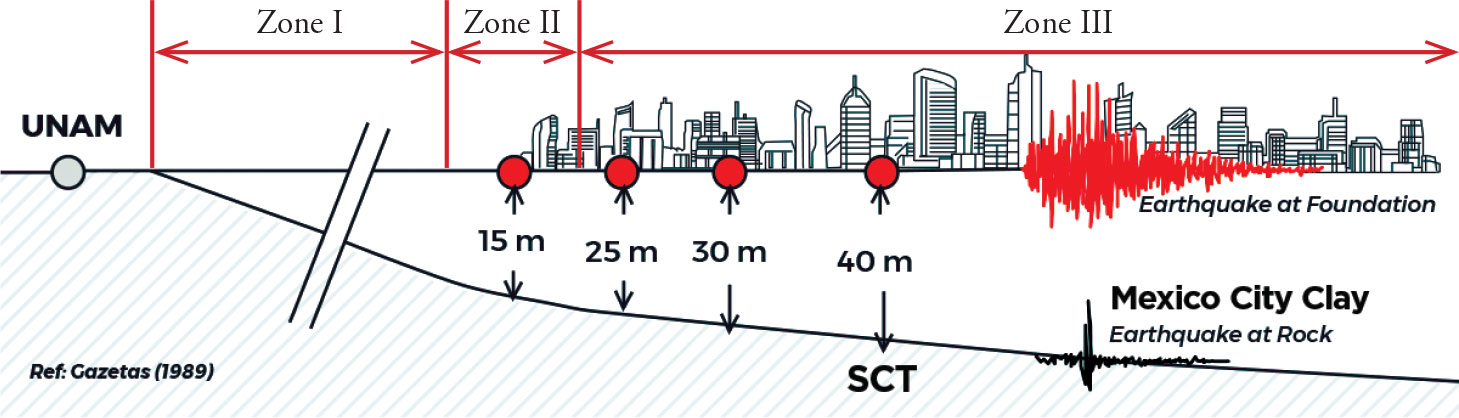
Figure 5. East-West section and code-specified seismic zones: Hilly (I), Transition (II), and Lake (III).
However, soil amplification in the lakebed is controlled primarily by the thickness of the upper soft clay that varies within the lakebed, as shown in Figure 5. Past events have documented striking soil amplification effects (Romo & Auvinet, 1992) attributed to the behavior of the soft clay deposit and particularly its high plasticity, PI, that controls the non-linear effects in soils. Vucetic & Dobry (1991) showed that the Mexico City clay behaves practically within the linear elastic range even for high shear strain amplitudes, γ, on the order of 10-3. This is accompanied by low damping, which means that the straining of the soil does not absorb the seismic energy and that it keeps being amplified as the waves propagate upwards within this layer.
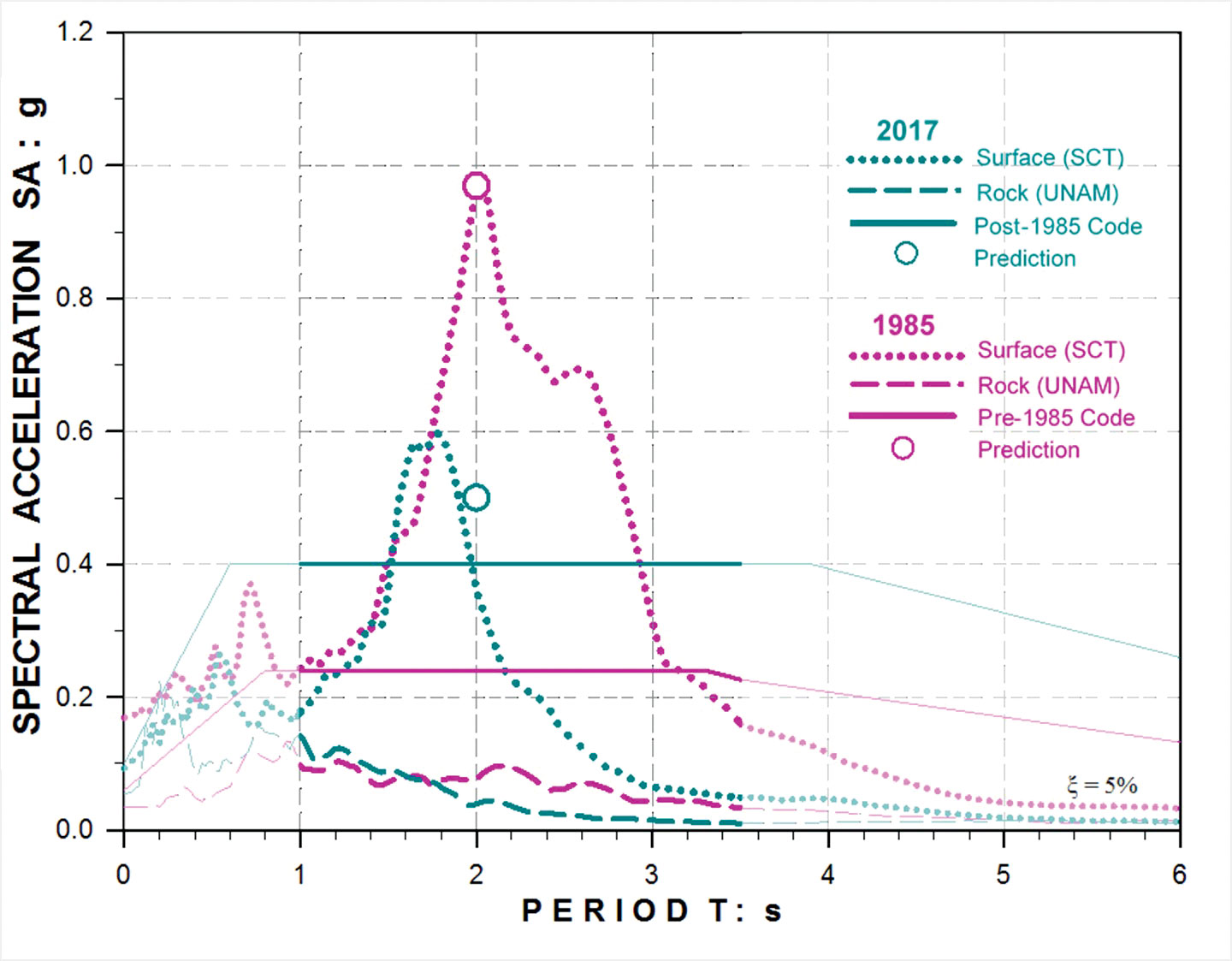
Figure 6. Acceleration response spectra from recordings at the rock (UNAM) and surface (SCT) stations in the 2017 (teal) and 1985 (pink) events.
Taking advantage of this unique characteristic offers the opportunity to understand the cause and the selective spatial distribution of damage by examining the soil amplification using simplified engineering approximations. Mexico City profiles may be generalized simply as a soil column of soft clay with Vs = 80 m/s (260 ft/s) and PI = 200 overlying the assumed bedrock at a depth H from the ground surface. Extensive analytical studies have validated this simplified approach, by Gazetas (1988) and the ATC reconnaissance geotechnical study for the Puebla-Morelos earthquake (Gilsanz & Nikolaou, 2018). The fundamental period of vibration for this soil column, Ts, equals 4 H / Vs. Using contour maps of the estimated Mexico City Ts offered in the local building code from micro-zonation (Ordaz & Perez-Rocha, 1992), engineers can estimate H and the primary vibration characteristics of the soil.
For example, the SCT site (Figure 5) is within the area of concentrated severe damage in 1985 and can be used to compare recordings and analytical predictions from the 2017 earthquake. The site has an H of 40 m (~130 ft) with an actual soil layering shown in Figure 6. However, this model is simplified with a uniform soft clay layer excited by motions recorded at a rock outcrop at the UNAM (National Autonomous University of Mexico) recording station for both the 1985 and the 2017 events. The relative similarity of the UNAM rock spectra, with a distinct high-period content, could be attributed to the roles of the large-scale geometry of the wider (≈ 10 km or 6 mi) and deeper (≈ 500 m or 1600 ft) lake basin (Singh et al., 1993) and the dense built environment of Mexico City that may cause building-to-building effects and elongation of the recorded motions.
To estimate the peak Spectral Acceleration (SA) at the surface, the known UNAM rock peak ground acceleration, PGA, is multiplied by an amplification factor, A. The fundamental soil period is Ts = 4 H / Vs = 2 seconds, and an approximate theoretical resonance amplification at that same period is A ≈ 11, assuming soil damping of 4%. The predicted peak SA at the SCT station site for this period would be SASCT(1995) ≈ A × SAUNAM(1995) ≈ 11 × 0.08 = 0.9 g, a value close to the maximum of the average spectrum from the two horizontal records of the 1985 earthquake (Figure 6). The agreement between observations and simple analysis is excellent, confirming the claim that it is the resonance of the soil deposit at T ≈ 2 seconds that is subjected to a high-period excitation and is rich at the period range 1.5 < T < 2 seconds. This produced the strong destructive ground motions of the 1985 disaster which targeted only buildings at this period range, as shown in Figure 5.
In 2017, the upper clay soil was probably slightly stiffer as the continuing consolidation increased its density and stiffness, validating the assumption that a smaller soil period of Ts ≈ 1.8 seconds is a reasonable approximation for this event. This produced the same amplification at the resonance of A ≈ 11 and a peak SA at the resonance at the SCT site, equal to SASCT(2017) ≈ A × SAUNAM(2017) ≈ 11 × 0.05 = 0.55 g, which is, again, in excellent agreement with the record. The response of the simplified soft clay profile with H = 40 m to the excitation of the 2017 UNAM record is also shown in Figure 6. While the soil amplification effects at the resonance period of the soil column of Ts ≈ 1.7 seconds are evident, the overall shape of the response spectrum deviates from the 2017 SCT record. This can be attributed to the limitations of the one-dimensional approach to a problem that is clearly three-dimensional due to the geometry of the lake. Overall, the records at the SCT site from both events have similar shapes, with the peaks shifted to lower periods and amplitudes in the 2017 event, which is to be expected due to the smaller amplitude and stiffer soil properties.
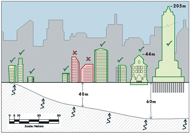
Figure 7. Concentrated damage in buildings highlighted in red in the 1985 disaster, due strong motions affected by soil resonance at T = 2 seconds and rich excitation between 1.5 and 2 seconds. Green-shaded buildings did not suffer significant damage.
The analytical predictions support the 2017 observation of minor damage at sites with a clay thickness of around 40 m (~130 ft), as shown in the buildings map of Figure 8 developed by the Geotechnical Extreme Events Reconnaissance (GEER) Association. This map shows collapsed buildings for the 1985 event in blue and the 2017 event in red, with the soil zoning of the Mexico City Building Code (OGDF, 2004) in the background. This demonstrates that the higher period and higher level of damage in 1985 was within Zone (III) of the city center, shown in Figure 5, concentrated at the northwestern part with H = 20 to 40 m (65 to 130 ft). The 2017 collapses were also within Zone III, but at the western part with H = 10 to 35 m (33 to 115 ft). The estimated peak SA design value for the post-1985 buildings was 0.4 g, almost double the 1985 design values of 0.25 g. This contributed to the improved structural behavior in 2017, with practically no collapses of post-1985 buildings.
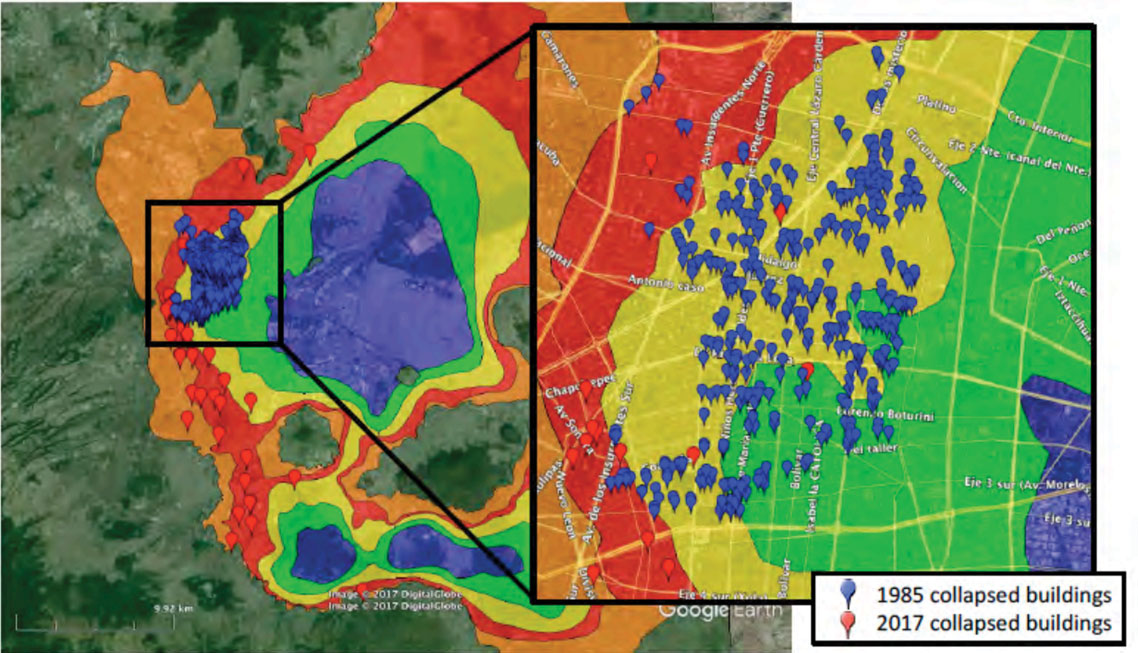
Figure 8. Collapsed buildings in 1985 (blue symbols) and 2017 (red symbols) on the contour map of soil zoning and vibration period (GEER, Mayoral, et al., 2017).
Observations and Conclusions
A very similar resonance phenomenon between the ground shaking and certain buildings occurred in both the 1985 Michoacán and 2017 Puebla-Morelos Mexico earthquakes. This was driven by soil amplification of the seismic waves due to the soft clay conditions, even though the two events had fundamental differences in magnitude, epicentral distance, and genesis mechanisms. However, the level of damage of the 1985 disaster was concentrated in the lakebed SCT recording station region with a fundamental vibration period of about 2 seconds, affecting buildings of periods between 1.5 and 2 seconds. The damage was substantially less in 2017, which can be explained by the smaller recorded accelerations that peaked in relatively shorter soil periods due to densification during the 32 years since 1985. Distinct high-period content of the rock motions could be due to the lake basin geometry and the dense construction that may have caused building-to-building effects. Both the lake and the density of construction may also have contributed to a longer duration of the seismic motions.
Overall, the lower ground motions, combined with the updates and enforcement of higher seismic design standards since 1985, played a significant role in the decrease of damage and the lack of collapses of post-1985 buildings in the 2017 event. The second part of this article will present: (i) geotechnical and structural design and building code evolution of Mexico City towards performance and resilient-based seismic designs of high-rise buildings over the last 20 years, and (ii) overcoming the challenges of going higher and digging deeper in this unique environment (Rahimian, 2017).■
Lexicon
ATC – Applied Technology Council
cm – centimeter
g – acceleration at the Earth’s surface due to gravity, equal to 9.81 m/s2
ft – feet; ft/s – feet per second
km – kilometers; km2 – square kilometers
m – meters; m/s – meters per second
mi – miles; mi2 – square miles
M – magnitude is a number that characterizes the relative size of an earthquake and is based on measurements of the maximum motion recorded by instruments. In addition to the well-known Richter scale, which measures local magnitude, two commonly used scales are (i) surface-wave magnitude (Ms) that reflects the amplitude of surface seismic waves and (ii) moment magnitude (Mw) that reflects the energy released. The two scales yield similar values for the same event.
NTUA – National Technical University of Athens
in – inches
OGDF – Órgano del Gobierno del Distrito Federal
SCT – Ministry of Communications and Transportation. One of the strong motion accelerometers is installed at the ground surface of the parking lot of the SCT building
wn – natural water or moisture content, equal to the ratio of the weight of water to the weight of the solids within the mass of soil
References
Avilés, J. and Pérez-Rocha, L.E. (2010). “Regional subsidence of Mexico City and its effects on seismic response,” Soil Dynamics and Earthquake Engineering, 30(10):981-989
Cervantes de Salazar, F. (1978). La Vida en México en 1554, 1555: México, D.F., Editorial Porrúa, 233 p.
Dobry, R. & Vucetic, M. (1991). “Effect of Soil Plasticity on Cyclic Response,” Journal of Geotechnical Engineering, ASCE, 117(1):
Gazetas, G. (1988). “The Role of Soil in the Mexico 1985 and the Kalamata 1986 Earthquakes,” Keynote Paper and Presentation, 1st Greek Conference of Geotechnical Engineering, 3:15-54.
Gilsanz, R. & Nikolaou, S. (2018). “ATC Mexico City Reconnaissance Report for 09/19/17 Mw7.1 Puebla-Morelos Earthquake,” Applied Technology Council (in print).
Mayoral, J., Hutchinson, T., Franke, K. (2017). “Geotechnical Engineering Reconnaissance of 19 Sept. 2017 Mw7.1 Puebla-Mexico City Earthquake,” Geotechnical Extreme Events Reconnaissance Association, GEER-055A, geerassociation.org, last accessed 5/29/18.
Nikolaou, S. “Site-Specific Seismic Studies for Optimal Structural Design: Part I – General,” STRUCTURE, February 2008. www.structuremag.org/?p=5854
Nikolaou, S. Valles, R., Shleykov, I., Diaz-Fanas, G., Rahimian, A. (2018). “Integration of Geotechnical and Structural Performance-Based Design for High-Rise Buildings in Mexico City, 11th National Conference on Earthquake Engineering, 11NCEE, Los Angeles, June 2018
OGDF (2004). “Normas Técnicas Complementarias Sobre Criterios Y Acciones Para El Diseño Estructural De Las Edificaciones.” Órgano del Gobierno del Distrito Federal, I(103-BIS).
OGDF (2017). “Gaceta Oficial de la Ciudad de México” Órgano de Difusión del Gobierno del Distrito Federal, Dec.
Ordaz & Perez-Rocha (1992). “Micro-zonation of Mexico City for Structural Seismic Design” (Spanish: Microzonificación de la Ciudad de México con fines de diseño símico de estructuras), funvisis.gob.ve, last accessed 12/14/17
Ovando-Shelley, E. Ossa, A., Santoyo, E. (2013). “Effects of Regional Subsidence and Earthquakes on Architectural Monuments in Mexico City,” Boletin de la Sociedad Geologica Mexicana, 65(1):157-167
Rahimian, A. (2017). “How to Resolve the Emerging Challenges of Tall Buildings Foundations?,” Ask a CTBUH Expert, Journal of Tall Buildings and Urban Habitat, Issue II,
Romo, M.P. & Auvinet, G. (1992). “Seismic Behavior of Foundations on Cohesive Soft Soils,” Recent Advances in Earthquake Engineering & Structural Dynamics, V., Davidovici, ed., Ouest Editions, ISBN 2-908361-22-7, Paris, France, 1:311-328.
Rosenblueth, E. & Ovando, E. (1991). “Geotechnical Lessons Learned from Mexico and Other Recent Earthquakes,” 2nd International Conference on Recent Advances in Geotechnical Engineering and Soil Dynamics: St. Louis, Missouri, II:1799-1819.
Singh S.K. and Ordaz M. (1993). “On the Origin of Long Coda Observed in the Lake-Bed Strong-Motion Records of Mexico City,” Bulletin of Seismological Society of America, BSSA, 84:1298-1306.
Tena-Colunga, A., Mena-Hernández, U., Pérez-Rocha, L.E., Avilés, J., Ordaz, M., Vilarb, J.I. (2009). Updated Seismic Design Guidelines for Model Building Code of Mexico,” Earthquake Spectra, 25(4):869-898
USGS (2017). Seismotectonics of Mexico, earthquake.usgs.gov, United States Geological Survey, last accessed 2/17/18.