
Past, Present and Future
Over the past twenty years, the seismic design value maps referenced by the building codes have undergone revolutionary changes, affecting the information they portray, the way they are developed and the design procedures that reference them. Many structural engineers, noting these constant changes and the effects on their designs, question why this happens and if it is necessary. This article presents a historic review of major developments in seismic design value mapping and a look forward to potential future changes.
Prior to 1993, U.S. building codes adopted seismic maps that portrayed design values in the form of seismic zones (Figure 1). The five seismic zones, each of which covered broad regions of the U.S., were based on the historic occurrence of damaging earthquakes, or the lack thereof; Zone 0 representing places where earthquakes had never been experienced, and were therefore deemed unlikely to occur; Zone 4 where major damaging earthquakes had historically occurred one or more times; and the intermediate zones covering places where ground shaking may occasionally have been felt, but where damage due to this shaking seemed less likely.
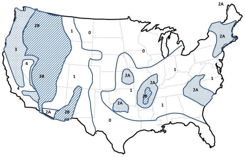
Figure 1. 1988 UBC Seismic Zone Map.
Originally, seismic zones and design forces were not quantitatively tied to anticipated ground accelerations. In the early 1900s, engineers in Italy, Japan and the U.S., without specific knowledge of the accelerations produced by earthquakes or the dynamic response of structures subjected to ground shaking, concluded that structures should be seismically designed to withstand 10% of their weight, applied as a lateral force should provide adequate protection. At that time, only buildings in places known to have severe earthquakes, including Los Angeles, Tokyo, and San Francisco, were designed for such forces. Later as building codes evolved, code-writers specified general use of the 10% criteria for structures in zones of severe seismic risk, and arbitrary fractions of this requirement for zones of lesser seismic risk. Still later, as engineers began to understand structural dynamics and spectral response, the 10% rule was adjusted to account for the reduced response of more flexible structures. At the same time, engineers observed that some types of structures, for example, unreinforced masonry bearing wall buildings, performed more poorly in earthquakes than others, e.g., frame structures. In response, codes specified structural quality factors to adjust the required design forces based on the type of structural system and the perceived enhanced capability of some structural systems to provide better performance. Finally, in the 1970s, code writers concluded that some structures, by reason of their occupancy and use, were more important than others and should be designed stronger, resulting in introduction of an occupancy importance factor. Throughout the 1970s and 1980s, seismic design forces were determined by the formula:
V = ZIKCSW
where Z is a zone factor, having a value ranging from 0 (in Zone 0) to 1 (in Zone 4); I, the occupancy importance factor, still with us today; K, a structural quality factor varying from 0.67 for structures having complete vertical load carrying space frames to 1.33 for “box” type structures wherein the shear walls carried most of the structure’s weight W; and C, a period (or height) dependent force coefficient, specified to result in a design forces equal to 10% of the structure’s weight for rigid structures of ordinary occupancy and ordinary framing located in Zone 4; and S a site factor, which increased design forces on soft soil sites. A nearly identical version of this formula was in use, without the occupancy importance and site factors, since the 1940s. Following the 1971 San Fernando earthquake and observation that some code conforming structures performed poorly, C was adjusted to provide an “ordinary” design force of 13% of the structure’s weight, and then following similar observations in the 1994 Northridge earthquake, 18% of the structure’s weight. Seismic design value maps continued to specify the Z coefficient, and geographic boundary of seismic zones based on the historic occurrence of earthquakes in broad regions. There was relatively little science underlying these requirements. Engineers determined design forces in an imprecise, but simple, way and the design forces in a given zone remained constant from code cycle to cycle, unless an extraordinary event, like a major damaging earthquake, suggested that force levels should be raised.
In the 1970s, the ATC 3-06 project initiated scientific quantification of mapped design values, abandoning seismic zone maps and adopting spectral response acceleration maps in their place. The ATC 3-06 report declared that design earthquake ground motions represented events with a 475-year mean return period and that the Zone 4 design motions had effective peak ground accelerations of 0.4g, a broad generalization given the huge variation in actual seismic risk across Zone 4. The ATC 3-06 report also recommended separate maps for short period and 1-second response accelerations, respectively denoted Aa and Av. Despite these conceptual differences, the ATC 3-06 maps resembled and retained much of the coarseness of the original seismic zones (Figure 2). Building codes adopted the ATC 3-06 recommendations slowly, retaining seismic zone maps into the 1990s. The codes did, however, adopt the concept that design ground motion represented 475-year shaking, and that design ground motions in Zone 4 had effective peak ground acceleration of 0.4g.
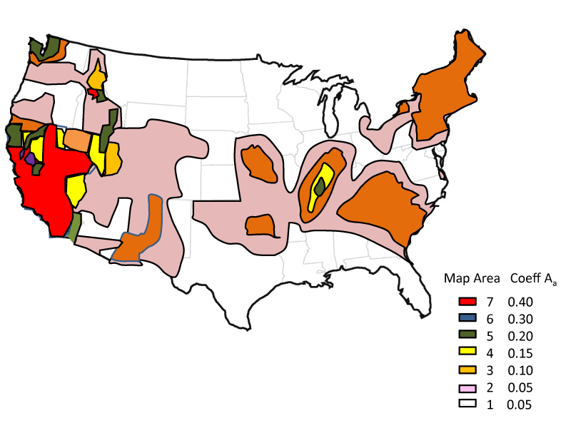
Figure 2. Aa map from ATC 3-06.
Paralleling the approach recommended by ATC 3-06, the 1988 Uniform Building Code (UBC) abandoned the base shear force formula in use since the 1940s in favor of a form similar to that found in present building codes. The Z and S parameters were dropped from the base shear equation but used to compute spectral response coefficients Ca and Cv, which replaced them. The structural quality factor, K, was abandoned in favor of the response modification coefficient Rw. Conceptually Rw represented the level of ductility, overstrength and damping inherent in different structural systems and the judgmentally determined ability of such structural systems to safely exhibit inelastic response. However, the Rw values were calibrated so that required design forces for different structural systems remained essentially unchanged from that required by earlier codes. Seismic zones were retained, with the Ca and Cv values derived over broad regions from the seismic zone factor and also the site characteristics. The base shear formula became more scientific, as did the commentary describing its basis, but design force levels changed little.
Starting in 1985, the Building Seismic Safety Council (BSSC) began to publish the NEHRP Recommended Provisions for Seismic Regulation of Buildings based on the ATC 3-06 report. This included a base shear formula like that contained in the 1988 UBC except that Rw was replaced with R to provide strength-level rather than allowable stress design level forces, and a larger number of structural systems, with unique R values, were defined. Unlike the 1988 UBC, the NEHRP Recommended Provisions included separate maps for Aa and Av. In 1993 both the BOCA and Standard Building Codes, used throughout the eastern U.S., adopted seismic design criteria and maps based on the NEHRP Recommended Provisions while the Uniform Building Code (UBC) retained the earlier criteria developed and maintained by the western states structural engineering associations, most notably SEAOC and SEAW. However, by 1994 it was clear that the three model code development organizations should collaborate to publish a single nationally applicable code, and that seismic requirements would be based on the NEHRP Recommended Provisions. Preparing for this merger, the Federal Emergency Management Agency hosted a series of joint Building Seismic Safety Council (BSSC) / United States Geologic Survey (USGS) projects to develop updated seismic design value maps for the new code. SEAOC and SEAW representatives also participated in these projects.
A key consideration in these joint projects was that 475-year return periods, while sufficient to capture most events likely to occur in the Western U.S. were not sufficient to capture credible ground shaking events in the eastern U.S. To avoid a major earthquake catastrophe in the eastern U.S., from a repeat of the 1811-1812 New Madrid earthquakes or the 1898 Charleston earthquake, it was felt that return periods on the order of a few thousand years were needed. A first attempt to develop nationally applicable seismic design maps and procedures, termed the Seismic Design Values Panel, failed to reach consensus. Ultimately, the second joint USGS/BSSC project (Project 97) developed a compromise solution resorting to 2,475 year return periods throughout the U.S., but capping the mapped values, deemed excessively high in regions near major active faults, with deterministic estimates of maximum likely ground shaking. Project 97 also introduced the concept of separately mapping short period and 1-second period response accelerations, now termed Ss and S1, in the form of contours, and developed the design procedure keyed to these values that still underlies ASCE 7 and the IBC today. The resulting maps appeared in ASCE 7-98, ASCE 7-02 and were referenced by the 2000 and 2003 editions of the International Building Code (IBC), then with slight revisions, were updated, republished and referenced by ASCE 7-05, and the 2006 and 2009 IBC editions (Figure 3).
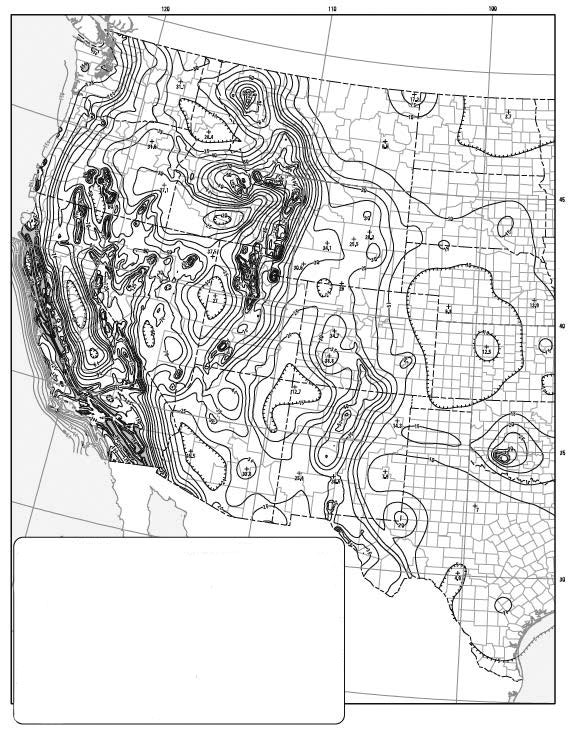
Figure 3. Ss map for the Western U.S. adopted in ASCE 7-05.
Significantly, the new maps showing contours for the Ss and S1 values were based on probabilistic seismic hazard analysis for every point on a 2 km by 2 km grid (approximately 1.2 miles by 1.2 miles) across the United States. These hazard analyses used the best available scientific knowledge to assess the values of these accelerations for a 2,475-year return period. Contours varied by 0.05g, and in regions close to major active faults were closely spaced such that, over a distance of a few kilometers, specified design values varied significantly. Not stated, nor generally understood by structural engineers, was the fact that the mapped values were inherently uncertain. While the mapped contour values represented “best” or mean estimates of the hazard at the 2,475-year return period, the statistical calculations underlying their derivation produced coefficients of variation of 60% or more. This uncertainty was a result of several factors, including a lack of knowledge as to the true locations of faults, the magnitudes of potential earthquakes on those faults and their activity rates, as well as unpredictable randomness in the prediction of ground acceleration values as a function of magnitude and distance. Scientific opinion as to the true value of these factors changed frequently and as these opinions changed, so too did the mapped values of ground shaking adopted by the building codes, such that with each successive building code edition, mapped values have alternatively increased and decreased, often without any real improvement in the certainty with which they have been calculated. As the mapped values of ground shaking parameters have changed, so have the required design forces for buildings, sometimes significantly from one code edition to another.
In 2007, FEMA partnered with BSSC and USGS once again to conduct a review of the basis for the seismic hazard maps and determine if updates to this basis were appropriate. Project 07, as the effort was called, resulted in conversion of the maps from a uniform hazard (2,475-year return period) for ground shaking to a uniform risk (1% annual probability of collapse) basis. Further, Project 07 decided that rather than using geomean motion as the basis for the maps, maximum direction motions should be used. The resulting revised maps appeared in ASCE 7-10, IBC-2012 and the pending IBC-2015. In 2014, USGS made revisions to the seismic hazard model underlying the maps, employing updated science, and published a new series of maps for reference by ASCE 7-16 and IBC 2018. Again, the specified design values in some locations changed significantly.
Noting the fluctuation in specified design values that occurs from code edition to code edition, structural engineers have expressed disbelief in the validity of the science upon which the maps are based and dis-satisfaction with the ever-changing design requirements for buildings. Further, as the definition of the maps has become more complex, designers have lost an understanding of the intent of the map, and what they represent. Importantly, the maps portray precision in the design values that is inappropriate, given the substantial uncertainty in the values portrayed. As a result of these concerns, the ASCE 7-16 committee was reluctant to adopt the latest edition maps. Recognizing these concerns, FEMA has sponsored a new joint USGS/BSSC project, termed Project 17, to once again evaluate the basis for the seismic design value maps referenced by the building codes. In addition to issues associated with updating the scientific basis for the maps, Project 17 will also address the issues of mapped value stability and portrayal of inappropriate levels of precision. The resulting maps produced by this effort will be referenceable by ASCE 7-22 and the 2024 edition of the IBC.
Project 17 initiated in 2015 with a planning effort that included educational webinars and outreach to the structural and geotechnical engineering professions. The resulting work plan includes a two-year effort that will focus on: 1) balancing the precision of mapped values against the uncertainty in their determination, with an intent to provide stability in future code-adopted maps, 2) the appropriate risk (or hazard level) to use as the map basis, 3) more accurate determination of spectral values for soft soil sites and long period structures, and 4) if still required, how to set deterministic caps on design values in regions close to major active faults. Other issues, including characterization of basin effects on spectra shape and values, consideration of strong shaking duration, and the use of simulated rather than recorded events as a basis for the maps, were considered; but they were deemed beyond the project’s scope given the available resources. If additional resources or data become available, the project may address these.
The intent is for Project 17 to provide direction to USGS on generation of the next issue of design value maps by late 2017. This will enable USGS to provide maps to BSSC for adoption into the NEHRP Recommended Provisions in time to support the development of ASCE 7-22 and for inclusion in the 2024 IBC. In the interim, ASCE 7-16 and the 2018 and 2021 editions of the IBC will incorporate seismic maps based on the USGS 2014 seismic hazard database.▪