
We had an Earthquake in Virginia – Now what?
The need to address regional aspects of the Eastern United States (EUS) in model building codes became even more evident with the 2011 Mineral, Virginia earthquake, the most felt event in modern US history, considering the extraordinarily large felt geographic area combined with a high population density. This article presents some facts of the 2011 earthquake that, when coupled with evidence from analytical studies and better understanding of the local geology and tectonic setting, highlight key seismic design issues that are not addressed sufficiently in present codes. The issues include seismic hazard mapping, site classification and procedures that dictate seismic detailing through ground motion acceleration limits and Seismic Design Categories. Current ongoing efforts to adjust the national procedures, specifically for the EUS, are discussed.
The 2011 Mineral, VA Earthquake
On August 23, 2011 an earthquake occurred in the state of Virginia (VA), with a magnitude of M5.8 and a maximum perceived intensity of VII on the Modified Mercalli Intensity scale. The epicenter was in Louisa County, 5 miles from the town of Mineral, 38 miles northwest of the state capital of Richmond and 84 miles southwest of Washington, DC. The shallow earthquake occurred within the top 4 miles of the earth’s crust, within the known Central VA Seismic Zone. It was the largest EUS earthquake since the M5.9 1897 Giles County, VA, event.
Details can be found in a report by the Earthquake Engineering Research Institute (EERI.org) [1]. The major effects of this earthquake, which caused no fatalities or significant injuries, can be summarized as follows:
Felt Area and Wave Attenuation
The main “felt area” extended more than 500 miles from the epicenter, making the 2011 VA Earthquake the most felt event in modern US history. Reports came from a maximum distance of 1,000 miles, an astonishing distance for an earthquake of this moderate magnitude, covering an area where more than one-third of the US population resides. The slow decay of this earthquake energy is a regional characteristic that can be attributed to the older, less worked, and harder regional bedrock that generates high frequency earthquake motions and that can travel great distances before they subside. To illustrate the comparison of EUS earthquakes vs. Western United States (WUS) earthquakes, Figure 1 presents the US Geological Survey (USGS) Did You Feel It? map from the VA earthquake and a similar event in magnitude (M6.0) from a California earthquake in 2004.
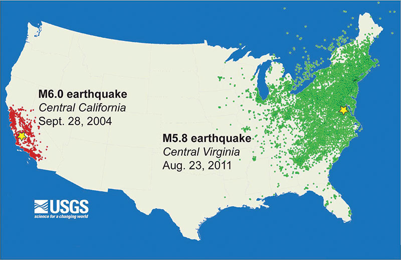
Figure 1: Comparison of USGS Did you Feel It? Maps from the 2011 M5.8 Mineral, VA (green) and the 2004 M6.0 Central California (red) earthquakes. Stars show epicenters and dots show locations where people reported at least weak shaking (usgs.gov).
Ground Motion Records and Geology
The attenuation of recorded Peak Ground Acceleration (PGA) values as a function of the distance from the epicenter is shown on Figure 2 from stations along the East Coast from South Carolina to Vermont. The records became available to EERI and the Geotechnical Extreme Events Reconnaissance (GEER) research teams from the Center for Engineering Strong Motion Data (CESMD) and the North Anna Nuclear Power Plant with the exact site conditions not known in detail.
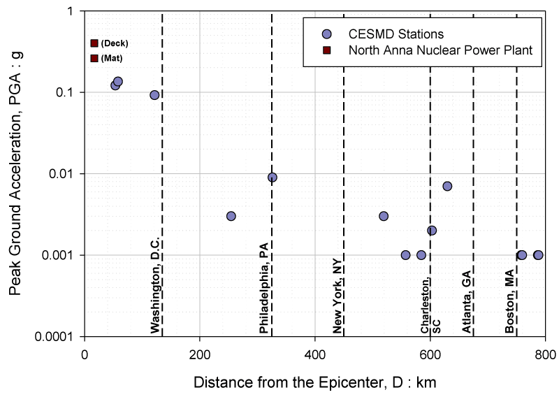
Figure 2: Peak Ground Acceleration (PGA) vs. distance from the Epicenter from CESMD and the North Anna Nuclear Power Plant stations.
The horizontal Spectral Accelerations (SA) for the records from four of the stations located within VA are shown on Figure 3 and are compared to contemporary local code-based SA for Site Classes C, D, E. Without exact station site conditions known, we cannot make firm conclusions on the directionality effects. However, it appears that stations located closer to the Fall Line (in proximity to Interstate 95) exhibited greater directionality than those located farther away, as shown in the motions from North Anna (NAP), Reston (RES), and Corbin (CBN) stations, which are close to the Fall line. The Fall line is a line that separates, geologically, the east coast into inboard bedrock areas and outboard cretaceous coastal areas (Figure 4). Some strong site amplification effects in the CBN station records may be due to site or topographic effects.
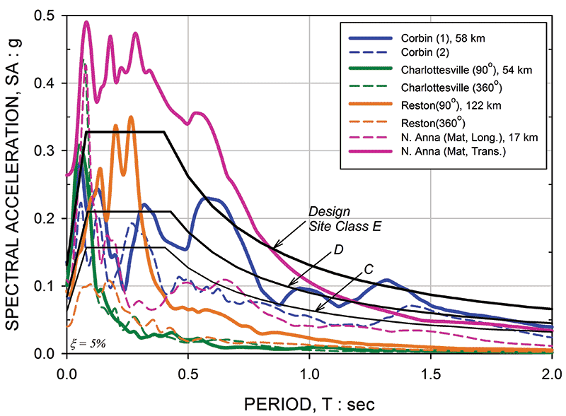
Figure 3: Acceleration response spectra from selected 2011 M5.8 Mineral, VA records. Black lines represent Site class C, D, E design response spectra from contemporary state building code based on IBC-06 (ASCE7-05).
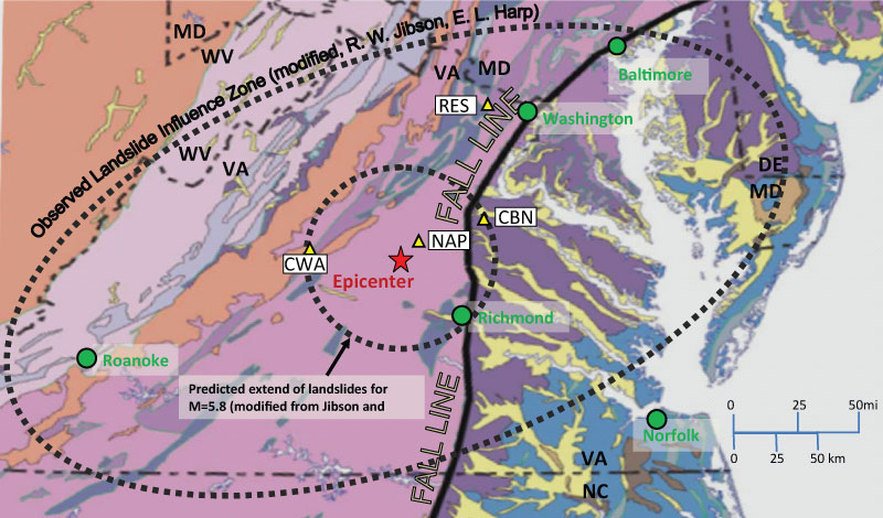
Figure 4: Map showing the Fall Line; epicenter; approximate observed limits in bold ellipse; previous max limit for same magnitude earthquake in circle around epicenter (modified from Jibson & Harp, 2012; base map from USGS National Geologic Map Database) usgs.gov.
Structural Damage
Widespread structural damage was observed, with the most common in unreinforced masonry walls, gable walls, and chimney breaks or collapses (Figure 5). Across Virginia, 33 residences were destroyed and 180 suffered major damage. Two schools were severely damaged, with the Louisa County High School having to convert into modular units five months later. In the Washington, DC area, the Washington Monument, the Smithsonian Institution, the National Cathedral, and Congressional buildings all suffered damage in addition to other private office and residential structures [1].
Heavier damage was observed in the coastal plain areas of south Maryland and Delaware, rather than at sites within the firm inland rock region that are closer to the epicenter. In this area of higher damage, relatively shallow soft deposits overlying the hard regional bedrock can create very large soil amplification effects that far exceed Code values that would affect mostly low-period structures [2]. Minor damages were reported as far away as in New Jersey and New York, which is more than 250 miles northeast from the epicenter, and in South Carolina, which is more than 370 miles southwest. Damage estimates were approximately $300 million overall, and on the order of $90 million in VA alone [1].
Nuclear Reactor
The North Anna Power Plant, just 11 miles from the epicenter, had to shutdown, activating backup power generation as SA and PGA values for the Operating and Design Basis Earthquakes were exceeded for Power Station Units 1 and 2 (Figure 2). The PGA at the foundations of the reactor containment reached 0.26 g with a design value of 0.12 g. No structural damage to safety components was identified, but non-critical components, such as the building’s concrete masonry unit (CMU) walls, exhibited hairline diagonal cracks, and 27 massive steel storage casks, for spent fuel rods, slid on their concrete slabs by as much as 4.5 inches.
Geotechnical Observations
While no large landslides occurred, many rock/soils falls were triggered at natural cliffs and steep road cuts with ground accelerations as low as 0.02 g to 0.04 g. In a comprehensive study published in December 2012 [3], the authors, Jibson & Harp, mapped the occurrence of rock falls. The distance limits for these occurrences reached 150 miles from the epicenter, exceeding by a factor of 4 observations from historic earthquakes with magnitudes of M5.8 in the WUS (Figure 4). The observations physically confirmed the lower attenuation of seismic waves in the EUS. Directionality was evident in this effect as well, with the affected area having an ellipsoidal shape, with lower attenuation parallel to the rupture. A few small liquefaction sand boils within Mineral were identified by the GEER team [4]. Soil effects due to the sharp stiffness contrast between soil and rock was evident. Other potential geotechnical evidence likely disappeared due to heavy rains from Hurricane Irene that followed shortly after the earthquake.
Non-Structural Components and Downtime
The earthquake tied up phone and internet connections, disrupted rail lines, and caused extensive traffic delays and business disruptions as far away as New York City. Non-structural components were affected, as seen in photos from the Louisa County High School (Figure 5). This could be expected since the immediate epicentral region would fall under low Seismic Design Categories that do not require significant non-structural components detailing.
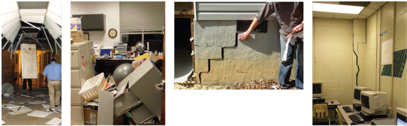
Figure 5: Masonry damage in Louisa County. Non-structural components damage from Louisa County High School (GEER Photos by R. Green, EERI Clearinghouse, eeri.org).
Response & Awareness
The earthquake caused widespread response confusion between public and emergency personnel, all of whom exhibited a lack of preparedness. Evacuation and rapid assessment procedures were either inconsistent or completely absent, even in medical facilities. Cell phone service and public transportation were disrupted, while airports and train stations were shut down immediately to assess damage. Several office buildings, including some in New York City (NYC), were evacuated. Social media were extensively used to communicate facts and experiences. Within 4 minutes of the quake, the word “earthquake” appeared in 3 million status Facebook updates. The Twitter rate was 5,500 messages/second, a rate similar to that seen immediately following the Tohoku mega-earthquake and tsunami [5].
Code Implications & Needs for Improvement
Lessons from the 2011 VA Earthquake can be used to revisit and improve certain code concepts and requirements for the EUS.
Seismic Hazard
The low decay and high frequency content of rock ground motions are taken into consideration in developing seismic hazard maps by using regional Ground Motion Prediction Equations (GMPEs) that estimate ground motion characteristics of PGA and SA as a function of magnitude and distance from the earthquake source. Due to the scarcity of recorded strong motions, GMPEs are mostly empirical or stochastic and, as a result, their predictions can vary significantly. For instance, SA predictions for a structure with period of 1 second for a typical M6.0 earthquake located at a site 10 miles from the epicenter, can vary from 0.03 g to 0.11 g, a difference of more than 300%. To address this very large variability, engineers usually resort to a relative weighting of the GMPEs and have to select hazard predictions significantly higher than the mean. A better consensus in the scientific community on regional GMPEs is needed for practical applications.
Site Effects & Classification
The applicability of code-based site coefficients, Fa and Fv, has been discussed extensively in this magazine [6,7]. Generic code site coefficients may not be representative of the behavior of regional soils, due to two main factors: (a) the sharp stiffness contrast of overburden soils with very hard bedrock, and (b) the bedrock motions, expected to be of relatively short duration, high frequency, and moderate intensity. Hence, if the soil is soft above the bedrock at shallow depths (say less than 100 feet), there will be resonance in the short period range, affecting mostly “short” or “stiff” structures with the relevant Fa code coefficient underpredicting soil amplification.
Indicatively, let’s assume a simple, shallow cohesionless soil profile with a code-classification of Site Class C or D, with a depth to regional hard bedrock (H) varying from 15 feet to 90 feet and with equivalent periods from 0.2 seconds to 0.6 seconds. The profiles were subjected to motions representative of the hazard in the NYC metropolitan area using the American Society of Civil Engineers’ (ASCE) Minimum Design Loads for Buildings and Other Structures, ASCE 7-05, guidelines [8]. Figure 6 shows that the equivalent Fa (orange lines) from the site-specific response is higher even than the highest code values [2].
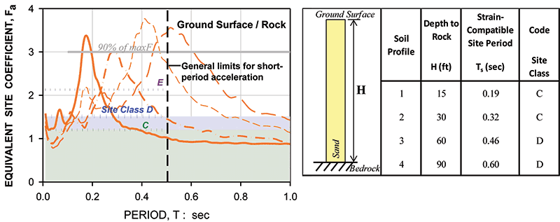
Figure 6: Equivalent site coefficient, Fa, and comparison with code-based Fa for a parametric study of idealized Eastern US sites (modified from Nikolaou et al, 2012).
Moreover, the site classification procedure is not appropriate in this case, as code guidelines allow for the inclusion of rock in site classifications of shallow sites. Specifically, ASCE 7-05 and ASCE 7-10 [8], Section 20.4 states: “Profiles containing distinct soil and rock layers shall be subdivided into… a total of n distinct layers in the upper 100 feet. Where refusal is met for a rock layer, Ni shall be taken as 100 blows/ft.” This allowance of incorporating a simulated rock layer as soil can lead to a “stiffer” more favorable site class with even lower Fa as compared to the classification using soil properties alone.
The importance of local geology, and the implications of being unconservative when generic procedures are followed, give timely opportunity for code modifications that can be complemented with data from the few valuable records from the 2011 Virginia Earthquake.
Seismic Design Requirements
Seismic Design Category (SDC) defines the required level of seismic structural analysis and construction detailing for structural and non-structural components, including electrical and mechanical equipment. It depends on the structural Occupancy Category (OC) and design acceleration levels [6]. In the EUS, the SDC ranges from “A” to the strictest “D.” The threshold design seismic coefficients values for each SDC (ASCE 7, Section 11.6) are based upon the correlations of these coefficients to the intensity and associated damage from the WUS data recorded, such as for the 1994 Northridge Earthquake, and are not necessarily applicable in the EUS, as the 2011 VA Earthquake intensity distribution has shown (Figure 1). Several large cities have seismic coefficients that are on the borderline with threshold limits between SDCs.
With the new generation of codes modeled after ASCE 7-10 [8], the basis for design is shifted from a uniform hazard (same probability of an earthquake to happen) to a uniform risk (same probability of a structure to collapse), using risk-targeted instead of hazard seismic maps. Once the map values are identified, subsequent procedures for determining SDCs and seismic loads remain practically unchanged, with an estimated reduction on the order of 10% to 15% as compared to ASCE 7-05. Such reductions are sufficient to classify sites into a lower SDC [9], hence requiring less seismic detailing. Using ASCE 7-10, many SDC’s would be reduced by one level in the Table below.
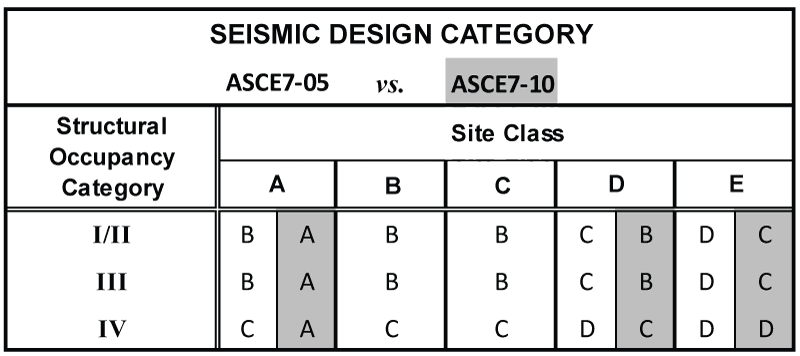
Typical regional shift (shaded in gray) in Seismic Design Category (SDC) when moving from ASCE7-05 to ASCE7-10 code basis.
Although these SDC comparisons are not direct because of the difference in design philosophies, the practical impact is a general lowering of SDCs in the Eastern United States. The relaxation of detailing requirements can impact the post-earthquake function of structures. Damage may be higher in non-structural components, such as ceiling-suspended electric/mechanical systems, that can affect the time needed for a structure to be serviceable after an earthquake (downtime), even in the absence of significant structural damage. This is particularly important for large cities with high population densities, whose downtime can have detrimental effects in their economy as well as the nation’s overall economy, as we saw following the 2011 VA Earthquake and in the dramatic effects of the 2012 Hurricane Sandy. Although ASCE 7-10 is an improvement towards performance and risk-based design, which should be welcomed in the EUS, a consideration of threshold limits for SDCs could be revisited to reflect EUS intensities of motions.
Actions for the Future and Conclusions
Because the Eastern United States is a region with moderate but highly unpredictable earthquake activity combined with a large percentage of structures lacking adequate seismic design, it is exposed to a high seismic risk with potentially significant socioeconomic effects. The 2011 Virginia Earthquake was a reminder that earthquakes do happen in this region and are felt at very large distances. It confirmed earlier scientific understandings and historic experiences that regional soils, bedrock, and earthquake motions have unique characteristics that warrant a reconsideration of the overall approach to seismic hazard and associated risk [10] and emergency response preparedness, and a revisit of code procedures for site classification and design and construction requirements.
Moving forward, practitioners and researchers agree on the need to update regional seismic analysis and design standards to reflect new science and engineering knowledge. Work is under way on a variety of topics, including: (i) the Next Generation Attenuation (NGA-East) research project is developing consensus ground motion prediction (or attenuation) equations, seismic hazard assessments, and characterizations of site responses (scheduled for 2014 [11]); (ii) the Earthquake Engineering Research Institute has recently established four local chapters with goals to bring awareness and education at all levels of expertise (engineering, geoscience, architecture, planning and social science) and to focus on reducing earthquake risk; (iii) the Multidisciplinary Center for Earthquake Engineering, in collaboration with the Structural Engineering Association of New York, has initiated studies to better understand vulnerabilities of typical, older NYC masonry construction; (iv) the American Society of Civil Engineers is updating the risk-targeted provisions of ASCE 7-10, with modifications for regional ground motions and soils effects.▪
The Author gratefully acknowledges the interaction with and material provided by her EERI, GEER, MCEER and ASCE collaborators, as well as contributions from her colleagues at Mueser Rutledge Consulting Engineers.
References
[1] EERI (Earthquake Engineering Research Institute) [2011]. “Learning from Earthquakes: The Mw 5.8 Virginia Earthquake of August 23, 2011,” EERI Special Earthquake Report, J. Beavers, & W. Anderson, co-leaders, December. www.eqclearinghouse.org/2011-08-23-virginia/files/2011/12/EERI-GEER-DRC-Virginia-eq-report.pdf
[2] Nikolaou, S., Go, J., Beyzaei, C.Z., Moss, C., Deming, P.W. [2012]. “Geo-Seismic Design in the Eastern United States: State of Practice,” Keynote Lecture, GeoCongress 2012, American Society of Civil Engineers (ASCE), GSP 226, March 25-29, Oakland, CA, Rollins, K. and Zekkos, D., eds.
[3] Jibson, R.W. & Harp, E.L. [2012]. “Extraordinary Distance Limits of Landslides Triggered by the 2011 Mineral, Virginia, Earthquake,” Bulletin of the Seismological Society of America, 102(6):2368–2377
[4] GEER (Geotechnical Extreme Events Reconnaissance) Association [2011]. Geotechnical Quick Report on the Affected Region of the 23 August 2011 M5.8 Central Virginia Earthquake near Mineral, Virginia, J.R. Martin, II, Editor & Team Leader, GEER Association Report No. GEER-026 www.geerassociation.org/GEER_Post%20EQ%20Reports/Virginia_USA_2011/index.html
[5] Kang, C. [2011, 8/23]. “Facebook, Twitter report record earthquake messages”. Washington Post. (accessed 8/25/11)
[6] Nikolaou [2008]. “Site-Specific Seismic Studies for Optimal Structural Design: Part I–General,” Structure magazine.
[7] Nikolaou, S. & Go, J. [2009]. “Site-Specific Seismic Studies for Optimal Structural Design: Part II–Applications,” Structure magazine
[8] ASCE 7—02/7—05/7—10 [2002/2005/2010]. Minimum Design Loads for Buildings and Other Structures, American Society of Civil Engineers, Codes and Standards Committee
[9] Dowty, S. & Ghosh, S.K. [2011]. “Seismic Design Provisions of ASCE 7-10: Changes from ASCE 7-05,” Structural Engineer Magazine, July.
[10] Morgan, T.A. [2012]. “Earthquake hazard, exposure, and risk in the Central and Eastern U.S.,” Structural Engineer Magazine, November.
[11] Goulet, C., Abrahamson, N., Bozorgnia, Y. (2011) “NGA-East final project plan,” PEER Center, University of California, Berkeley