
Humans and Drones Must Work Together
The increased use of drone technology over the last several years has had a positive impact on the field of civil engineering. Drone-based sensing technologies enable engineers to inspect large-scale infrastructure systems faster, and from angles that were previously inaccessible. Drones equipped with reality capture technologies, such as cameras and scanners, promise to be an effective apprentice to inspectors and engineers. These “assistants” will be collecting spatial data about large infrastructure systems at the resolution needed to give engineers a complete picture of infrastructure conditions during both construction and inspection.
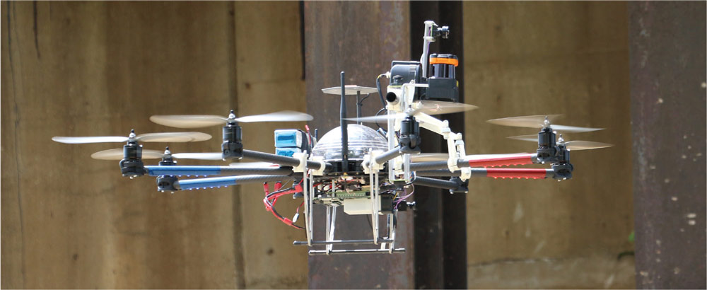
ARIA robot fitted with various sensors and an onboard computer, to aid autonomous navigation as well as collection of laser scans and images.
When pieces of essential infrastructure, like bridges, need to be inspected or repaired, the process often causes significant disruptions in the community. Shutting down a full bridge, or even just a few lanes, for the weeks or months needed for manual inspection, data collection, and assessment can have negative impacts on traffic patterns and greatly increase travel times. As such, the general practice up until this point has been to perform these checks only during low traffic periods, resulting in stretched out project timelines and turning what could normally take a week into months of on and off disruption.
Traditional bridge inspection methods come with safety risks. Surveying the underside of a bridge often requires hanging inspectors over the side using service cranes, sometimes hundreds of feet above the ground. On top of that, many parts of the inspection rely on the inspector’s judgment and experience to accurately assess the bridge’s condition, rendering the collected data inherently subjective. Finally, manual data collection targets specific areas where issues are observed or considered most likely and naturally cannot provide comprehensive data about the full spatial condition of an infrastructure system.
As drone mounted reality capture technologies have advanced, it has opened the door to safer, more efficient, and more accurate methods of data collection to support inspection. These aspects enable such systems to act as the inspectors’ apprentice, supporting many decisions made throughout the life cycle of an infrastructure system.
Research conducted at Carnegie Mellon and Northeastern University, called Arial Robotic Infrastructure Analyst (ARIA), aims to streamline these drone-based data capture technologies and create an effective engineer’s apprentice. This interdisciplinary multi-university research uses a tabletop-sized drone, with onboard photo and video capture techniques and state of the art laser scanners, to create a high-resolution, fully immersive 3D model of a bridge, which can then safely be analyzed by an inspector on the ground. The goal is to perform an overall assessment quickly and alert inspectors to particular problem areas. From there, the human inspector can go in and more thoroughly assess problem areas, without having to inspect every inch of the bridge physically.
This process allows the collection of inspection data much more quickly, safely, and autonomously. From the ground, an inspector can instruct the ARIA drone to collect data covering the entirety of an infrastructure system or focus on just a specific portion. Algorithms then process the collected point cloud and image data and identify problem areas on which inspectors/engineers can concentrate. This way, inspectors/engineers can not only do a virtual inspection but also have access to processed data that highlights possible damage. Because the drone does not need to use the roadway, bridges can remain open during the inspection, and any necessary shutdowns are dramatically shorter. Moreover, it is not only bridges; ARIA can be used to inspect dams, transmission lines, or any complex, large-scale infrastructure where speed and safety are a high priority.
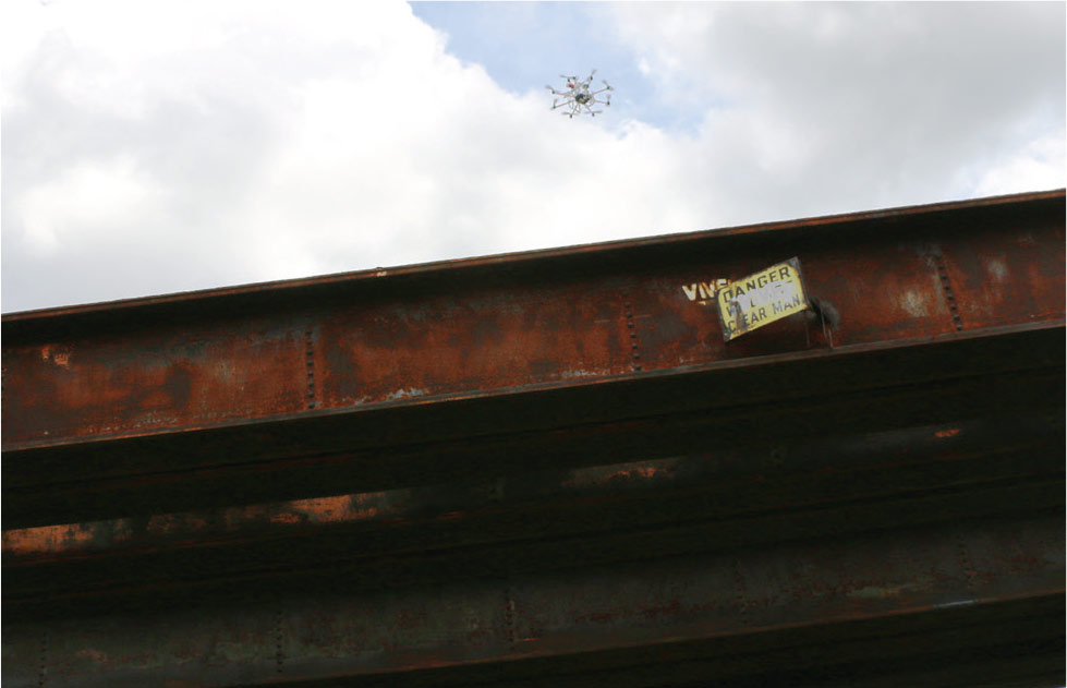
View of the steel girder railroad bridge at the Robot City Roundhouse (Hazelwood, PA), used as one of the testbeds in this research project.
As this technology proliferates, regulations will need to change not only as they relate to drone usage, but in other aspects of inspection as well. Under current practices, a human inspector must be in physical contact with a bridge during an inspection for it to be considered reliable. However, as drones become able to not only fly and scan, but to latch onto an infrastructure system for other kinds of sensing as well, inspectors could perform full inspections remotely, using the drone or other robotics systems as their eyes, ears, and hands. This kind of advancement, which would further increase safety for inspectors and decrease inspection times, will only be possible if policymakers choose to keep up with these new capabilities.
In addition to time and safety concerns, the sheer wealth of collected data from drones will allow those in charge of maintaining the infrastructure to focus their energy better – and their money – on the areas of most desperate need. It is possible to make operations, maintenance, and retrofit investments most effectively utilizing accurate and more comprehensive data.
While the benefits do show great promise for the future of inspection, the technology is not without its downsides. When large amounts of data are introduced, people tend to over-rely on the data. In this case, the worst thing you can do is to assume that the technology is 100% comprehensive and accurate – because it may not be. ARIA is not designed to replace a human inspector’s expertise and analysis, but instead to be a more objective and comprehensive data collection and assessment tool for engineers. As with any technology, when people blindly follow the data, the margin for error increases.
For example, if the drone were to create a full scan of the bridge, there may be small areas of the bridge, either underneath or between supports, which may be occluded from the drone’s view. Any damage in these areas would not be reflected in the data. If inspectors were to take the data at face value, instead of using it as a starting point from which to complete a faster and more accurate inspection, they would report no damage to the bridge, when in reality, it is entirely possible there is damage. Hence, inspectors need to be equipped with a good understanding of what these technologies can or cannot do in order to make the most of the technology advantage while not jeopardizing assessment results.
Future adopters of drone technology will have to strike a balance. These tools have the ability to provide faster, safer, and more accurate data. However, they are just that – tools. If we allow the data to replace the inspector, we run the risk of misrepresenting bridge health, defeating the purpose of data collection, and allowing infrastructure conditions to worsen. If used properly, however, drone technology can help us maintain large infrastructure systems with greater speed, safety, and reliability – at a much lower cost.▪