
How Earthquake Early Warning Systems Can Aid Recovery Efforts
Buildings and residents near the Salton Sea began shimmying and shaking during the swarm of earthquakes that burst from Bombay Beach in late September 2016. Soon, the California Earthquake Prediction Evaluation Council (CEPEC) released a statement. It read: “CEPEC believes that stresses associated with this earthquake swarm may increase the probability of a major earthquake on the San Andreas Fault to values between 0.03 percent and 1.0 percent for an M7.0 or larger earthquake occurring over the next week (to 09:00 hrs PDT, Tuesday, October 4, 2016).” The Twitterverse lit up with nervous Kermits, earthquake maps, and visits to snopes.com to confirm the rumors. That the advisory came just weeks before the annual ShakeOut drill, it served both as a solid reminder that earthquakes can happen at any time and also demonstrated that communicating earthquake hazard is complicated.
The uncertainty that the Southern California public felt during this period of heightened probability for a significant rupture was palpable. The between 33 to 1000-fold increase in the likelihood of an M7.0 or higher event seemed awfully high but, at the same time, a 0.03-1% chance of a rupture seemed quite small. What mitigation actions are appropriate given these numbers? As scientists who do this sort of thing for a living, this was reminiscent of another earthquake advisory that was put out in L’Aquila, Italy. A seismic swarm began in the region in early 2009 and, after the main shock of April 6, 308 people had died and six scientists were charged with manslaughter. The scientists were ultimately acquitted, but the fact remains that communication of increased earthquake probabilities is a dicey subject. Most earthquake swarms do not culminate in a large main shock, as seen in the Salton Sea area, but they can be a precursor.
The ideal solution, of course, would be the ability to predict earthquakes before they happen and pinpoint precisely the affected populations, the size of the rupture, and the exact time that the shaking would begin. Other natural disasters afford citizens this luxury, where people can be evacuated for a fixed period of time, houses and businesses can be secured, and when it is over, recovery can begin. However, for earthquakes, which do not happen on the same recurrence scales that other disasters do, models rely on current, past, and paleoseismic catalogs to infer recurrence rates and increased stresses on certain faults to define probabilities that an event of a certain size will happen in the future.
California publishes the results of these models in the Uniform California Earthquake Rupture Forecast (UCERF, see Figure 1). The current models indicate that the Northern San Andreas fault has a 33% chance of experiencing an M6.7 or greater earthquake during the lifetime of a mortgage loan. That is important for people considering earthquake insurance on their home, cities retrofitting their infrastructure, or for the general knowledge that it is not a matter of if, but when an earthquake will happen. However, unlike earthquake prediction, such forecasts do not provide acute actionable information about imminent threats. The timescales are so large that apathy can set in.
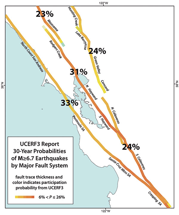
Figure 1. Summary of the earthquake rupture probabilities for the major faults in the Bay area. Courtesy of Jack Boatright, USGS.
So, the natural next question is: are forecasts the best that modern technology can provide? No. Thankfully there is another tool available. Well, to be fair, it is currently available in Japan and Mexico, and only experimentally on the West Coast of the United States, but it does exist. ShakeAlert and its partners (Figure 2) are working hard to ensure that tool is widely available as soon as possible. The tool is earthquake early warning.
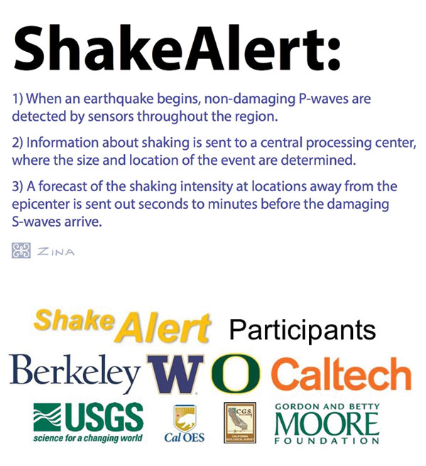
Figure 2. Shake Alert and Partners.
The ShakeAlert Earthquake Early Warning (EEW) system in the United States uses a network of seismic instruments to detect the very first signals that a rupture has begun (Figure 3). The energy emanating from a rupture forms two main wave trains. The P-wave is a compressional wave and is considered ‘non-damaging.’ The second wave train begins with the S-wave and is followed by Love and Raleigh waves. These are associated with much of the damage the built environment experiences during a rupture. The P-waves travel at twice the speed of the S-waves so, as the energy moves away from the epicenter, the P-waves begin to outrun the S- and following waves. ShakeAlert detects the amplitude, frequency, and time for the P-wave. This information is analyzed at a central processing center, which calculates the expected magnitude, location, and origin of the quake, and forwards that information to emergency responders, utilities, transportation centers, and others so that they can take protective action before the heavy shaking reaches their location (Figure 3). ShakeAlert also estimates the local shaking intensity through the use of a UserDisplay, so that users obtain tailored information about shaking thresholds they are likely to experience.
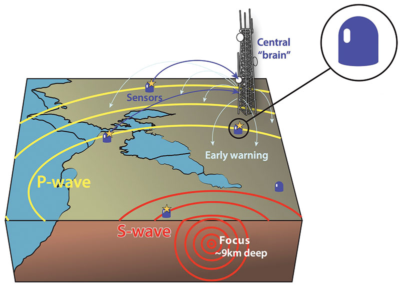
Figure 3.
This advanced warning is of critical importance not just for times of calm before a large event, but also during both swarms and aftershock sequences. Residents of both Bombay Beach and L’Aquila were rattled by the low-intensity shakes that seemed to go on forever. For each shake, citizens were unsure whether the intensity would remain small, or if it would ramp up into a larger damaging event. EEW can bring peace of mind in those situations by providing information for larger events so that people know to drop, cover, and hold on. Swarms can psychologically destabilize an area by their constant shaking, while a large event followed by intense aftershock sequences can physically destabilize a region. First responders sifting through the rubble of the collapsed Cypress Viaduct after the 1989 Loma Prieta, CA quake were aided by a proto-EEW system. USGS and Caltrans installed a combination of sensors, temporary communications systems, and receivers to give about 20 seconds of advanced notice to the workers that an aftershock was about to arrive. Even small to moderate shakes can have a severe impact in areas already compromised by a larger event. In this way, EEW hastens recovery efforts by protecting the workers.
The 20 seconds of warning the Caltrans workers received was because they were about 90 km from the aftershocks centered in the Santa Cruz Mountains. Had they been closer, the alert time would have been shorter, perhaps even no advanced warning at all. However, even at that distance, the shaking was strongly felt due both to the soft sediment in the area, which amplified the shaking, and the fact that, for moderate to large earthquakes, the epicenter is not the only point of rupture.
Small to moderate earthquakes behave like a rock thrown into a pond. Concentric circles of disruptive waves emanate from the spot the rock met water. The waves get weaker as they move out, barring local eddy effects. Moderate to larger earthquakes are more like a tree branch falling into the pond. There is one initial point of contact with the water (the epicenter), but the branch keeps falling and making contact with the water all the way to the ends of the leaves. The once concentric and orderly rings are now a whole series of overlapping rings that can add onto one another and cause larger waves to reach the shore, even far down the pond from where the branch first fell in. Thus, people far away from the epicenter can both have larger warning times and experience high levels of shaking.
Typically, when speaking of EEW, the first use case that comes to mind is “drop, cover, and hold on.” EEW alerts can trigger trains to slow and stop, reducing derailments. Firehouse bay doors can open automatically to ensure the trucks can exit promptly. Gas shutoff valves activated, lithography tables put into safe modes, school children taking shelter under desks, halting cars at bridge plazas, securing radioactive sources in hospitals – there are many use cases being explored today. EEW in the built environment augments these sorts of automated controls with pre-hazard planning to streamline the recovery effort.
Like the workers on the Cypress Viaduct, building inspectors assessing red and yellow tagged buildings after an event are vulnerable to aftershocks. As the sequence progresses, and hopefully dies down over time, the areas most impacted by each subsequent shaking event would be identified through early warning, even if the epicentral locations migrate over time. Estimated shaking intensity profiles would allow for prioritization of areas to inspect. This, combined with pre-hazard planning and use of scenarios and drills, could provide a set of protocols, vetted well beforehand, that could be selected based on the early warning information.
ShakeAlert is facilitating this pre-hazard planning through partnerships with pilot groups. In February of this year, the ShakeAlert group invited selected beta testers to begin establishing protocols and actions in response to EEW alerts. This allows utilities, schools, and large infrastructure groups to start developing their responses for various scenarios, at the same time as the system build out is underway, to test and validate these actions before the public system goes live. As part of the pilot launch, ShakeAlert transitioned to a production prototype system. This robust and redundant system removes single points of failure such that if one data center goes offline, another steps in to take its place, providing smooth and continuous information to the users.
ShakeAlert currently relies on approximately 760 seismic stations throughout the West Coast to provide real-time information to the system. New station installations combined with upgrading older stations to real-time capabilities will ultimately get the system to the target of 1,675 stations. The locations of the current seismic stations used for early warning are shown as blue disks, while the proposed future station locations are depicted as green triangles in Figure 4. This configuration will provide dense network coverage around known active faults and population centers, while still providing moderate coverage in other areas (to catch unknown faults, like the one that generated the 1994 Northridge earthquake).
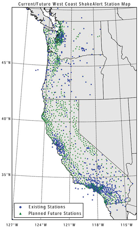
Figure 4. The current and proposed future stations for the ShakeAlert earthquake early warning system are plotted here for the entire West Coast. The blue disks denote current active stations, while the green triangles are proposed locations for new and upgraded installations.
ShakeAlert is halfway there, both in terms of funding and installation of the station build-out. However, ShakeAlert will not become a fully public system unless it can complete the station build-out, secure long-term sustained operational funding, and meet certain reliability standards for the warnings. The build out is proceeding, with more stations added every year. The operational funding, both from state, private, and federal sources, has increased over the years and hopefully will continue on a path towards a sustained public safety initiative. Since large to moderate earthquakes do not happen every day on the West Coast, ShakeAlert must use a combination of real-time, archived, and synthetic data to stress-test the system reliability. The U.S. is in a unique position – most of its earthquake hazard lies beneath most of its large population centers. The ShakeAlert algorithms must therefore delicately balance the need to have accurate information, with very few false alerts, while at the same time using the smallest amount of data possible to make the determination and provide the most warning. Metrics are currently being established, and the system will be tested against those metrics before any public alerts go out.
Currently, the system uses seismic algorithms to characterize the earthquake. These P-wave based approaches have limitations. They tend to saturate above M8, and they require the rupture to initiate before alerts are generated. Thus, there is always a limit to the amount of early warning provided. ShakeAlert is working to addresses these issues by combining the operational aspects with academic research. Testing of Global Navigation Satellite System techniques, such as Berkeley’s GlarmS algorithm, will allow the system to punch past the M8 limit by modeling the movement of the fault plane in real time. Berkeley also works on fundamental research into earthquake initiation processes which, while not part of EEW at this time, could increase understanding and provide new techniques for the future. Earthquake prediction is not possible with the data and understanding currently available, but it is a young science. The future may herald new insights and discoveries that make techniques beyond P-wave detection faster and more reliable.
EEW is an important tool in the preparedness toolkit. Both the Japanese and Mexican early warning systems provide an apparent benefit to those populations. However, it is important to remember that early warning works best when combined with other tools, such as retrofits, automated controls, and pre-hazard planning. People and physical assets are better protected in secure buildings that remain standing after the rupture. Automated controls can spin up with an early warning alert, moving people and things into safe modes to prevent cascading failures that hamper post-event recovery. Moreover, of course, pre-hazard planning allows for training on what to do when an earthquake strikes. Early warning just gets you there faster.▪