
On January 10, 2015, a refinery in Lima, Ohio suffered a catastrophic failure resulting in an explosion. This explosion reportedly rattled windows as far away as five miles. Following suppression of the fire, the investigation into what caused the explosion commenced. However, investigators probing the debris field were faced with the challenge of documenting the layers of damage relative to each other in three dimensions. Furthermore, as the investigation progressed, much of the debris that was not related to the fundamental cause had to be removed. Removal of the debris can be problematic if later in the investigation these materials are found to have contributed to the causation and proper debris documentation has not been secured. This scenario is common in massive explosions and structural failure cases. Investigators must approach debris fields carefully, all the while preserving the location and condition of the evidence as it is encountered in the field. Unmanned Aircraft Systems (UASs or drones) can map and document these complex debris fields without disturbing the physical evidence. As a result, drones are becoming a go-to tool for the forensic engineering industry.
Increasing Popularity
The usage of UASs in the United States has increased significantly, varying from recreational pursuits to commercial endeavors. The technology associated with drones is rapidly evolving allowing for more autonomous operation of these vehicles. Because the vehicles themselves operate independently, the Federal Aviation Administration (FAA) has created specialized certifications for operators of UASs (FAA Section 333 Exemption) with 5,537 granted as of July 19, 2016. The Association of Unmanned Vehicle Systems International (AUVSI) reported that over 180,000 drones have been registered with the FAA as of June 1, 2016. Recently, the FAA has relaxed the regulations regarding drone usage; operators no longer need to be licensed pilots, resulting in increased opportunities for the use of drones in the forensic market.
Events occurring in and around airports where drones have nearly collided with aircraft highlight the dangers associated with the use of drones in terminal control areas. Despite the risks, drones offer several advantages enticing the utilization of these technologies in numerous industries. The growth in the consumer market alone is estimated to more than quadruple over the next five years. Given the rapid expansion in the availability of individual platforms and the associated technological growths, the use of drones is certain to spread throughout the forensic engineering industry.
Drone Technology
Drones are available in several configurations, from hand-launched aircraft configurations to rotary-wing type vehicles. For obvious reasons, the rotary wing configuration (Vertical Take Off and Landing, or VTOL) offers significant benefits when inspecting buildings and confined spaces, as this platform allows stationary observation of individual items of interest. These VTOL platforms are often characterized by the number of rotors attached to the frame, such as quad-copter or hex-copter.
Currently, drones are often utilized to capture aerial images and measure distances, areas, and volumes in the mining industry. Commercially available photogrammetry software (a process that is fundamentally based on triangulation between points in numerous images of the same subject, taken from differing directions), coupled with the aerial platform of a drone, can produce horizontal accuracies of plus or minus 1.2 inches and vertical accuracies of plus or minus 2.0 inches. Higher resolutions are reported, but hard documentation of these higher resolutions was unavailable. Significant placement of ground reference targets is required for higher resolutions. Additional cameras such as infrared devices are also mounted on drones, producing relevant documentation of fire scenes and critical water intrusion/roofing inspections.
As technology has evolved, terrestrial laser scanning systems have been miniaturized and mounted on UASs. This technology is commonly referred to as LiDAR (Light Detecting and Ranging) and can produce resolutions approaching 0.2 inches or less of XYZ coordinates in a point cloud.
The LiDAR technology is based on laser scanning and is highly useful when paired with drones in a forensic investigation. Frequently, terrestrial-based laser scanning is utilized in the design and construction market to document structures for Building Information Modeling (BIM). LiDAR, as applied to early forms of BIM and infrastructure, was pioneered by Departments of Transportation through the usage of bulky laser scanning instruments mounted on tripods and paired with cameras.
The laser scanning technology has since advanced, and modern instruments are significantly smaller and more lightweight offering up to a one million point-per-second scan rate. However, terrestrial-based laser scanning does not capture detail from above. Hence, shadows, where the laser beam is obstructed by target items, exist. Because complex debris fields demand scans from above to maximize the scan coverage, multiple instrument setups are required to overcome these shadows. Furthermore, to utilize terrestrial-based scanning, one must physically access the area surrounding the items of interest to set up and level the instrument. This physical access becomes problematic when structures are damaged, the items of interest are within a collapse zone, and access is unsafe. Therefore, the pairing of LiDAR systems with drone technology becomes attractive.
Research into fully autonomous drones has rapidly advanced when combined with onboard artificial intelligence. While this technology is still under development, piloted drones are currently being implemented to scan large debris fields, damaged structures, and remote infrastructural elements such as powerline systems for inventory management as illustrated in Figure 1.
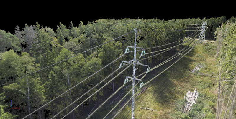
Figure 1. Aerial scan of transmission line using photogrammetry.
Major limiting factors applicable to a drone system’s flight time are weather, payload, and battery power. The time to map an individual site at a low resolution is significantly less than that required at a high resolution; a shorter time-on-station is required. High definition scans require multiple passes over the same area of interest. Of note, navigation of a drone into a partially collapsed structure requires a significant amount of time to accomplish high-resolution scans, and the power demands associated with this longer flight time are high. The ingress and egress and the energy demands associated with the lighting and instrumentation package can severely limit overall flight durations and tasking. As battery technology advances and the power density in a given battery volume correspondingly increases, time-on-station and payload capabilities will certainly increase.
Industry Usage
Numerous insurance carriers are developing drone systems for deployment. As of April 2015, three insurance carriers have been granted FAA approval to operate drones in the United States. Moreover, forensic engineering firms have also obtained FAA clearance for the use of drones. Given the intensely competitive nature of the insurance and forensic engineering markets, the intended use of the drone systems is generally not disclosed. However, drone and scanning technologies are ideally suited for activities like aerial surveying and mapping. Specifically, identified usages include:
- Roof Investigations
- Building Envelope Investigations
- Fire and Explosion Investigations
- Catastrophe Assessment
- Underwriting Surveys
Drones are ideally suited for providing useful information in a disaster such as wide-area surveys of the extent of damage from windstorms, mudslides, tornadoes, and hurricanes. Reports of drone use for forensic hail and wind investigations are often suggested as a means to reduce costs and minimize site expenses. However, a drone cannot probe a suspected hail impact site for bruising, nor can a drone lift an individual shingle tab to determine whether or not the tab is disengaged from the substrate. As such, drones have limited applicability to wind and hail surveys other than standard documentation of visible damage. Causation relative to visible damage still requires access and inspection by a human hand. While drones can measure roof surfaces, commercially available sources provide this service for a reasonable fee. In contrast, drones excel when tasked for wide-area surveys and surveys of inaccessible sites on individual buildings.
Probably the most readily identifiable use of drones in the forensic engineering and claim adjusting market involves the documentation of damage in inaccessible areas. For instance, the failure of a rigging system in New York City while lifting new HVAC components into a high-rise structure produced damage in highly inaccessible areas. Inspection of the damage in these areas required special equipment and specially trained individuals. Installation of this specialty equipment, such as swing-stage scaffolding, can take months to schedule, deploy, and install. The usage of a drone platform in this instance, while not employed, could have accelerated the damage evaluation. However, the complexities of deploying a drone in the New York City airspace precluded the use of this valuable tool at that time. In similar cases, drones equipped with high-resolution cameras and LiDAR could potentially inspect the damage and provide useful documentation of quantities for the adjustment of the claim within days. Furthermore, the high-resolution images could be utilized in a forensic engineering investigation to determine the extent of damages and the required potential repair methodologies. Notwithstanding the possible advantages, the deployment of drones in dense urban areas and secure sensitive installations such as harbors is problematic and requires at least the approval of all involved parties, and police and fire departments. Also, navigating drones capable of flying in gusty wind environments surrounding buildings is troublesome, given the lightweight nature of the vehicles.
A less complicated application of photogrammetry and laser scanning utilizing drones is dramatically illustrated by research performed by the University of Nebraska, Lincoln following a tornado. In this research, faculty members used a drone to capture point cloud data of a damaged school building as shown in Figure 2.
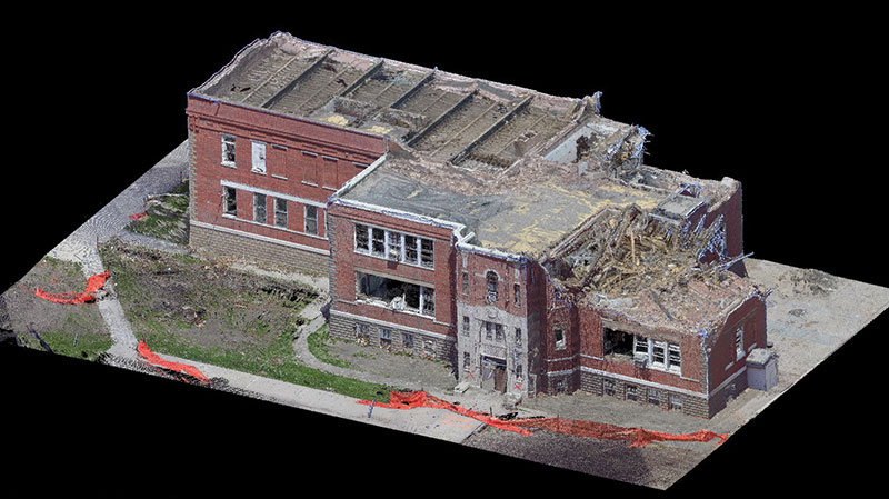
Figure 2. LiDAR scan of damaged school following a tornado. Courtesy of Richard Wood from the University of Nebraska-Lincoln.
This three-dimensional digital model exists in cyberspace and can be the basis for accurately acquiring quantities and measurements. The model can be viewed through a secure, online digital portal by anyone associated with the job. Furthermore, the high-resolution nature of the digital model lends itself to excellent communications with clients regarding the scope of damage and resulting cost of repair. Without drones, this level of data collection would require extensive effort and would lead to a much lower quality level of documentation for the client.
While extensive work is still required within the interior of the structure, the gross characterization of the damage from the exterior of the structure was obtained rapidly (significant post-processing is necessary to render a digital model). The use of drone technology clearly presents advantages in illustrating dangerous areas surrounding the structure and documenting the limits of damage for cost estimation purposes. The image provided by the University was based on the use of high-definition cameras, and a LiDAR 3D scanner mounted on a drone platform.
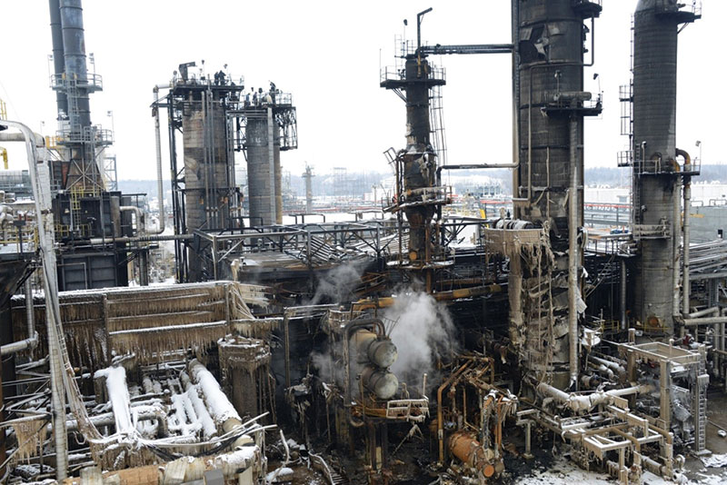
Figure 3. Complex debris field.
Not only is the creation of a virtual model of a structure following a disaster critical for cost estimating purposes, but it is also important for the preservation of evidence. Often, a failure results in large debris fields that are challenging to reconstruct and document. The position, orientation, and condition of each piece of debris can be critical to understanding the failure scenario. Each piece of debris must be thoroughly documented before it is moved to preserve the evidentiary value of the components. Drones are uniquely suited to mapping the debris field with a high level of accuracy from an aerial perspective, without disturbing the scene, and in a rapid fashion. Additionally, the aerial perspective provided by drones allows for a rapid assessment of the debris so that any evidence is not overlooked and the limits of the scene can be secured. Subsequent flights are made as the investigation moves forward and debris is moved to access critical failure locations. Refinery losses and structural failures with large debris fields, such as those illustrated in Figures 3 and 4, illustrate the unique applicability of drones in these complex and scattered debris field failure scenarios.
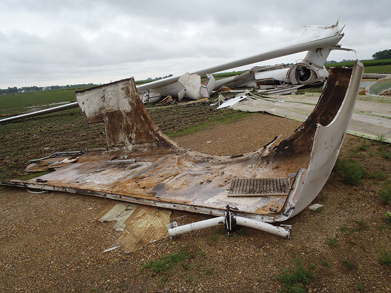
Figure 4. Localized debris field following wind turbine over-speed, due to mechanical failure within the nacelle. Remnants and evidence were found 650 feet (198 meters) from the tower base.
Finally, one further potential usage of drones is related to the regular façade inspections that modern cities require. These inspections identify loose and damaged materials, most often in masonry claddings. Loose cladding material may fall on pedestrians and represent a growing hazard in the as-built urban environment. For example, on April 13, 2015, a section of façade collapsed in downtown Cleveland resulting in property damage. Currently, these types of inspections are performed by engineers and technicians rappelling down the face of the building. Drones, while facing limitations discussed previously relative to wind and hail inspections, could provide a faster, more economical initial inspection with less intrusion, and therefore represent an improvement on the current practice.
Additional opportunities to use drones include pier and wharf inspections, property condition assessments, environmental site evaluations, vehicle accident reconstruction, and pre-loss documentation. The sky is the limit when it comes to applications for drones in the forensic engineering industry.▪
References
Association of Unmanned Vehicle Systems International (June 1, 2016). Drones Take to the Air at CES, Promoting Safety. www.auvsi.org/blogs/auvsi-news/2016/01/06/ceshuerta (July 15, 2016).
Business Insider (June 10, 2016). The Drones Report: Market Forecasts, Regulatory Barriers, Top Vendors, and Leading Commercial Applications. www.businessinsider.com/uav-or-commercial-drone-market-forecast-2015-2 (July 15, 2016).
Jessica Menton, International Business Times (May 31, 2015). NYC Crane Collapse: Several Injured As AC Unit Plunges Nearly 30 Stories In Midtown Manhattan. www.ibtimes.com/nyc-crane-collapse-several-injured-ac-unit-plunges-nearly-30-stories-midtown-1945532 (July 15, 2016).
Leslie Reed, University of Nebraska, University Communications (June 16, 2015). Engineers study how Pilger tornado destroyed buildings. http://news.unl.edu/newsrooms/unltoday/article/engineers-study-how-pilger-tornado-destroyed-buildings (July 15, 2016)
Cliff Pinckard, Northeast Ohio Media Group, Cleveland.com (April 13, 2015), Unstable building facade forces closure of downtown Cleveland streets. www.cleveland.com/metro/index.ssf/2015/04/unstable_building_facade_force.html (July 15, 2016).